LEXINGTON, Ky., August 20, 2015 — A $6 million National Science Foundation grant will allow researchers at the University of Kentucky, Oklahoma State University, University of Oklahoma, and University of Nebraska to develop unmanned aircraft systems, otherwise known...
1Spatial Platinum Sponsor at BCS “ SoC Mapping Together Conference 2015
Cambridge, UK, August 20, 2015 — (www.1spatial.com) 1Spatial, the global spatial software firm which manages the world’s largest spatial data, will be a Platinum Sponsor of the BCS – SoC Conference 2015, an event bringing together The British Cartographic...
INTERGEO Once Again the Largest Meeting Point for UAS Exhibitors
Stuttgart / Karlsruhe, August 19, 2015 — The INTERGEO from 15 to 17 September in Stuttgart looks set to provide among others with “interaerial SOLUTIONS†platform the most comprehensive overview of unmanned aircraft systems (UAS) to date. The trend in these...
ASPRS Launches New Lidar Certification
Bethesda, Md., August 19, 2015 — The American Society for Photogrammetry and Remote Sensing (ASPRS) certification program announces the launch of a Professional and Technologist LIDAR Certification, the Certified Mapping Scientists, Lidar (CMS, Lidar) and the...
New Cowboy State Maps Add U.S. Forest Service Data
August 19, 2015 — Newly released US Topo maps for Wyoming now feature more trails using data provided by the U.S. Forest Service such as the recreational trails in the Bridger-Teton National Forest. “The USGS has expanded an excellent working relationship with the...
Textron Systems Promotes Daryl Madden to Geospatial Solutions' Senior Vice President and General Manager
PROVIDENCE, R.I., AUGUST 19, 2015 — Textron Systems, a business of Textron Inc. (NYSE: TXT), announced today the promotion of Daryl Madden to senior vice president and general manager of its Geospatial Solutions business. He reports directly to Textron Systems...
French Energy Company SPIE Chooses SuperPad To Enhance Survey Efficiency
August 19, 2015 — Supergeo, the total GIS software solution provider, announces that SPIE, France, chooses SuperPad, the mapping application designed for Windows Mobile, to empower its streetlights and other utilities survey works. SPIE, the European leading company...
Blue Marble Exhibits at FutureView 2015 Conference and Technology Summit
Hallowell, Maine, August 19, 2015 —Blue Marble Geographics will be exhibiting at the FutureView 2015 Conference and Technology Summit hosted by Pictometry International Corp. in Nashville, TN from August 19-21. The latest advancements in Pictometry® Imagery, 3D...
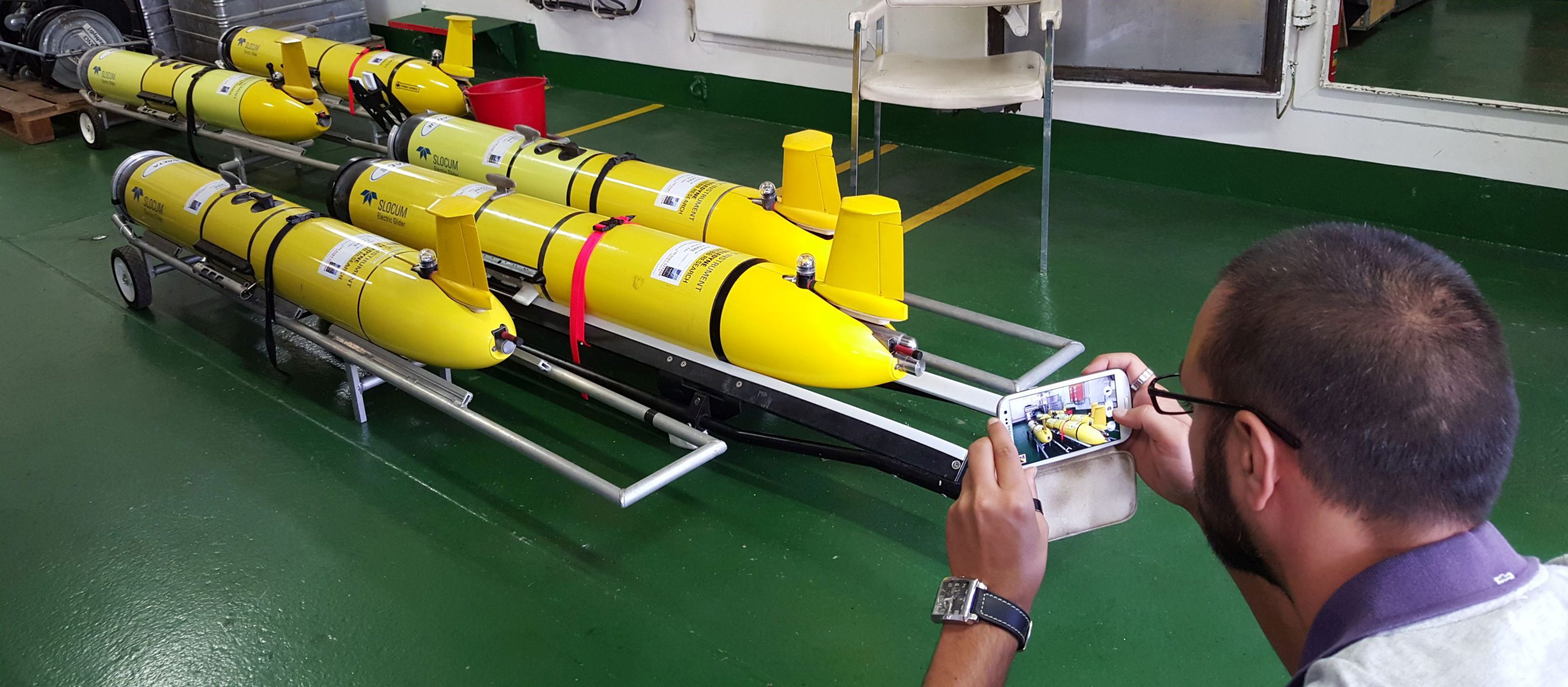
Maritime Research Center ˜Listening to Seas'
Scientists from the NATO STO Centre for Maritime Research and Experimentation (CMRE) and their partners from nine institutions of five NATO nations (Canada, Italy, Norway, United States and United Kingdom) will collect acoustic, oceanographic and geophysical data using traditional and novel observation methods, such as underwater gliders.
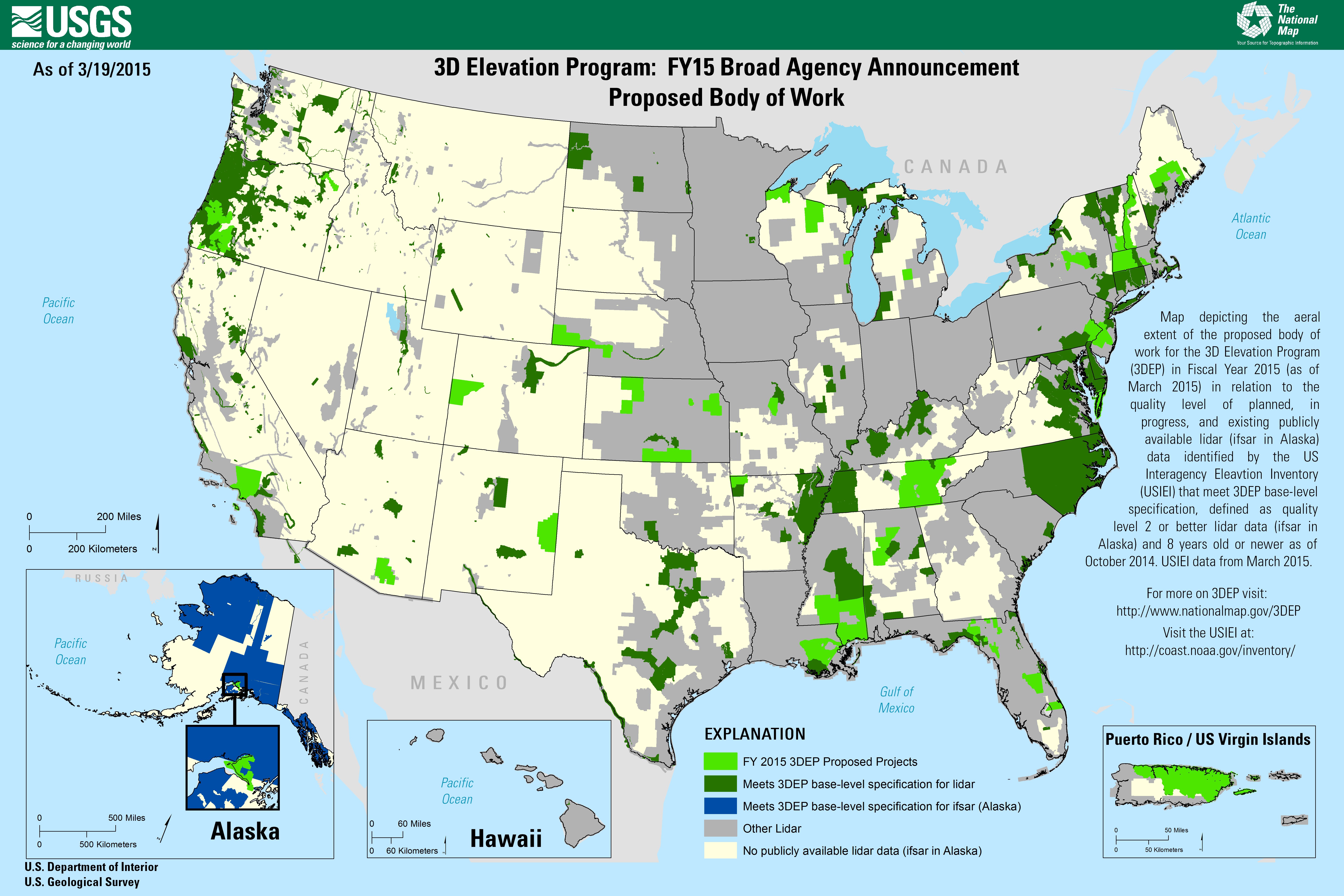
Dewberry to Evaluate New LiDAR Technologies for 3DEP
Under its Geospatial Products and Services Contract with the U.S. Geological Survey (USGS), Dewberry is executing a task order to evaluate two new forms of LiDAR to determine if single-photon LiDAR (SPL) and Geiger-mode LiDAR (GML) can satisfy USGS LiDAR Base Specification version 1.2 for quality level (QL2) LiDAR for use in the USGS 3D Elevation Program (3DEP).
