A new, official height for Denali has been measured at 20,310 feet, just 10 feet less than the previous elevation of 20,320 feet which was established using 1950’s era technology. With this slightly lower elevation, has the tallest mountain in North America shrunk?...
FAA Selects New Unmanned Aircraft Executives
September 2, 2015 - The Federal Aviation Administration (FAA) has selected Marke “Hoot†Gibson and Earl Lawrence for two executive-level positions that will guide the agency’s approach to safe, timely and efficient integration of unmanned aircraft systems (UAS)...
PCTEL Launches New GNSS Micro Helix Antenna Series in Europe and U.S.
BLOOMINGDALE, Ill., September 2, 2015 - PCTEL, Inc. (NASDAQ:PCTI), a leader in Performance Critical Telecom solutions, announced the commercial availability of its GPS/GLONASS high performance asset tracking and synchronization helix antennas. These antennas capture...
Locata Positioning Will Underpin Future Unmanned Aerial System Research at NASA’s Famed Langley Research Center
CANBERRA, AUSTRALIA and LAS VEGAS, NV, September 2, 2015Â -Â Locata Corporation announced today that NASA plans to install a Locata network (LocataNet) as the core positioning technology for safety-critical Unmanned Aerial Systems (UAS) research at its world-renowned...
Sanborn Bolsters Industry-Leading 3-D Offerings
COLORADO SPRINGS, Colo., September 2, 2015 - The Sanborn Map Company, Inc. (Sanborn) continues to broaden its massive 3-D data collection, including the exciting new option to provide centimeter-accurate 3-D modeling of any building interior, from giant warehouses,...
Independent Mapping Consultants (IMC) to Acquire Carolina Resource Mapping (CRM)
WILMINGTON, NC, SEPTEMBER 2, 2015 – Geospatial mapping firm Independent Mapping Consultants, Inc. (IMC) recently announced its acquisition of the Wilmington, North Carolina based firm, Carolina Resource Mapping, Inc. (CRM). The CRM team offers experienced...
Blue Marble Announces Featured Speakers for Upcoming 2015 User Conference
Hallowell, Maine – September 2, 2015 - Blue Marble Geographics (bluemarblegeo.com) has an impressive list of featured speakers for the 2015 Blue Marble User Conference (BMUC) coming to Arlington, Virginia. The sixth Blue Marble User Conference, this is the first...
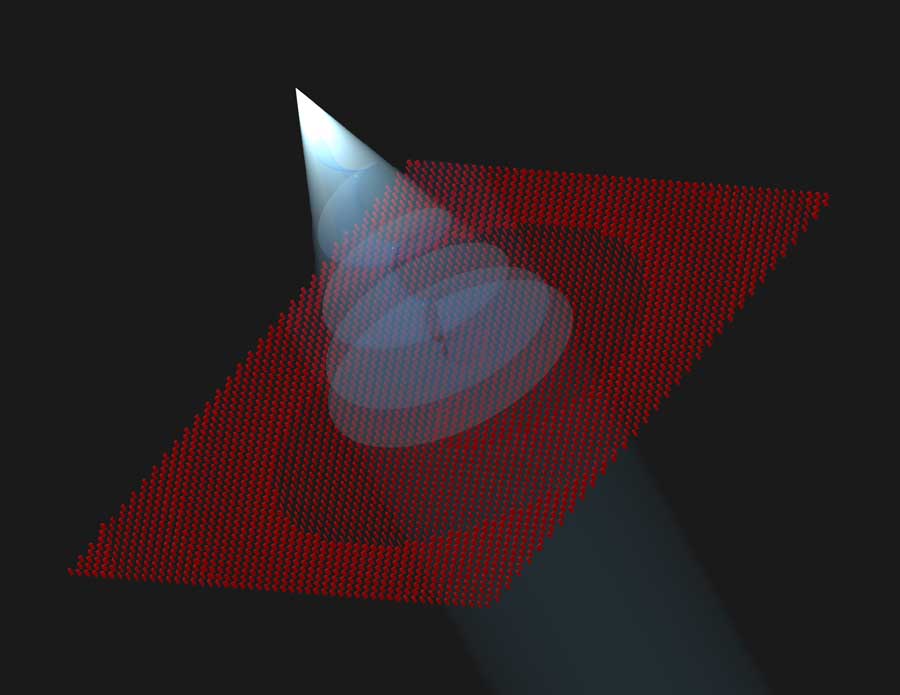
New, Ultrathin Optical Sensors Shape Light in Exotic Ways
Researchers have developed innovative flat, optical lenses as part of a collaboration between NASA's Jet Propulsion Laboratory and the California Institute of Technology. These optical components are capable of manipulating light in ways that are difficult or impossible to achieve with conventional optical devices.
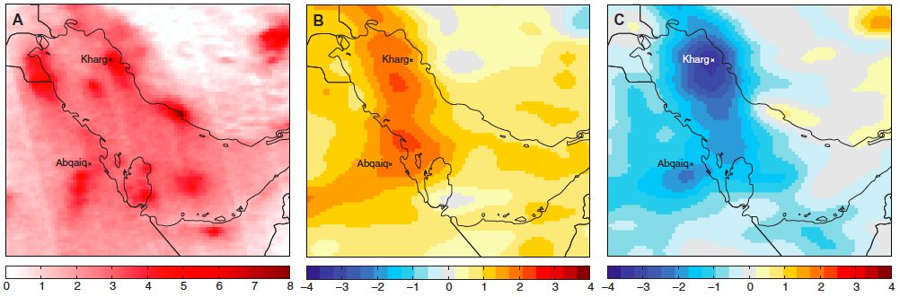
Satellite Spots Unexpected Result of Middle East Conflict
If there's any silver lining to the ongoing conflict in the Middle East, it may come in the form of fewer smog clouds. Political upheaval, economic recession and armed conflict over the last five years drove down air-pollution levels, especially smog, across the Middle East, according to an open-access report published recently in Science Advances.
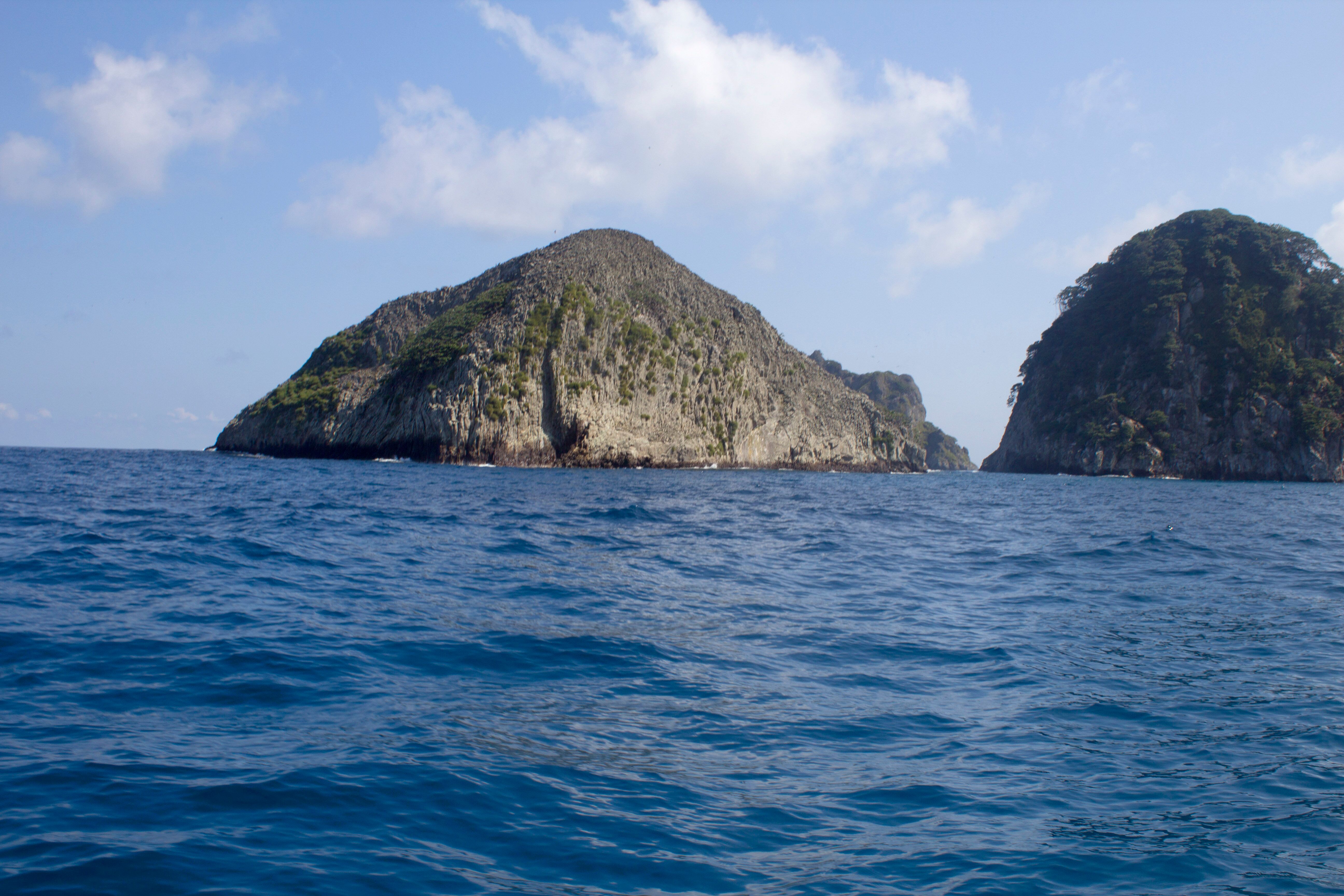
Crowdsourcing to Spot Illegal Fishing Vessels at Cocos Island Marine Protected Area
Turtle Island Restoration Network (SeaTurtles.org) partnered with DigitalGlobe's crowdsourcing platform (Tomnod.com) to create the first crowdsourced digital patrol of the Cocos Island Marine Protected Area to defend one of the Pacific Ocean's most-vibrant marine-life habitats.
