October 8, 2015 — Hexagon, a leading global provider of information technologies that drive productivity and quality across geospatial and industrial enterprise applications, recently was awarded the first- and second-place prizes in the Wichmann Innovations Award...
FAA Expands Unmanned Aircraft Pathfinder Efforts
October 7, 2015 — The Federal Aviation Administration (FAA) has entered into a Pathfinder agreement with CACI International Inc. to evaluate how the company’s technology can help detect Unmanned Aircraft Systems (UAS) in the vicinity of airports. In...
Trees Tell Story of Regreening of West African Grasslands
October 7, 2015 — Regrowth of trees explains why grasslands in western Africa known as the Sahel have recovered after devastating droughts in the 1970s and 1980s, according to South Dakota State University professor Niall Hanan. The Sahel is a semiarid region with...
Geospatial Research Program Seeks Project Applications
FAYETTEVILLE, Ark., October 7, 2015 — The Spatial Archaeometry Research Collaborations (SPARC) Program, a National Science Foundation-funded initiative at the Center for Advanced Spatial Technologies at the University of Arkansas, is accepting applications for...
Assessment of the Small-Satellite Market – Reportlinker Review
NEW YORK, Oct. 7, 2015 — This market insight covers the small-satellite market from an Earth-imaging standpoint. It touches on the research and commercial versions of small-satellite technology. Other domains such as in-orbit debris mitigation and satellite-based...
Orbit GT to Showcase New UAS Mapping Product at UAS Expo, Las Vegas
Lokeren, Belgium, October 7, 2015 — Orbit GT will be showcasing its new UAS Mapping product at the UAS Expo in Las Vegas, this week. “We’ve been in the UAV business for over 8 years now, and we’ve seen it grown from scratch.â€, says Peter Bonne, CEO of Orbit...
R.A. Smith National Given Green Light from FAA on Commercial Use of Unmanned Aircraft System (UAS)
October 7, 2015 — R.A. Smith National — a nationwide, multi-disciplined civil and structural engineering and surveying firm — headquartered in Brookfield, Wis., has been granted a Section 333 Exemption from the Federal Aviation Administration (FAA). This...
Eye on Earth Special Initiatives Demonstrate Critical Role of Data for Sustainable Development
Abu Dhabi, October 7, 2015 — At the second Eye on Earth Summit in Abu Dhabi today, experts highlighted the achievements of the movement’s Special Initiatives in providing data, tools and frameworks to help inform decision-making for sustainable development. The...
Bluesky Completes Project to Laser Map East Anglia and the South East
Leicestershire, October 7, 2015 — Bluesky has completed a multi-million pound aerial mapping project to assess the impact of vegetation on the electricity network of East Anglia and the South East of England. Working on behalf of UK Power Networks, Bluesky...
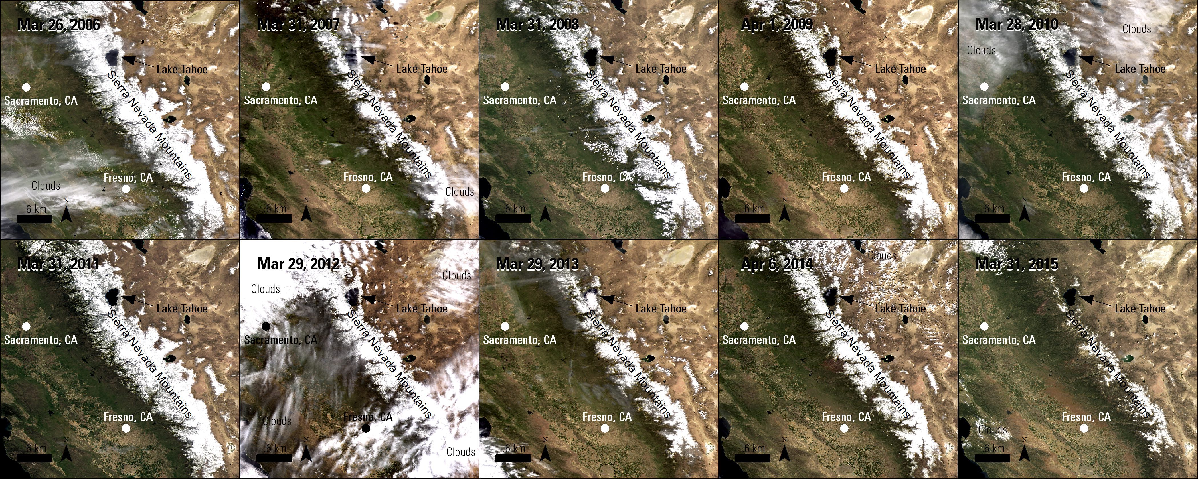
Remote Sensing Helps Observe Drought in California
California is in its fourth consecutive year of drought, which impacts water in the state in many ways. The main sources of consumable and agricultural water for California are underground aquifers, reservoirs and mountain snowpacks, but in recent years the volume of water in these sources has been decreasing.
