October, 20, 2015 (France) — Lehmann Aviation (www.lehmannaviation.com) released its new long range data modem, compatible with all L-A Series drones. With this new functionality, L-A Series drones (especially the LA300 for mapping and surveying) gain the same...
Global Mapper LiDAR Module V17 Released with New Noise Filtering and Power Line Extraction Tools
Hallowell, Maine, October 20, 2015 — Blue Marble Geographics (bluemarblegeo.com) is pleased to announce the immediate availability of an update to the Global Mapper LiDAR Module. Offered in conjunction with the recent release of Global Mapper version 17, Blue...
Teledyne Optech Boosts Presence in China with General Manager Wenjie Wang
October 20, 2015 — Teledyne Optech is pleased to announce that Wenjie Wang has joined the company in the position of General Manager for China. In his new position, Wenjie will work in Teledyne’s growing office in Beijing to provide his in-depth experience to...
First annual Commercial UAV Expo gets Sky-High Marks from Industry Insiders
October 19, 2015 (Portland, Maine, USA) — Commercial UAV Expo’s launch October 5-7, 2015 was lauded as a huge success for precision measurement professionals who gathered for three days of education, networking, and buying and selling solutions at a conference...
Eye on Earth Summit Calls for Practical Actions to Support Informed Decision-Making and the 2030 Sustainable Development Agenda
Abu Dhabi, October 19, 2015 — The second Eye on Earth Summit, held last week, has concluded with a commitment by delegates to implement a number of mechanisms, recommendations and practical actions around the supply, demand and enabling conditions of data considered...
Exclusive Keynote Presentation at the Capturing Reality Forum in November
October 19, 2015 — The The Capturing Reality Forum, which takes place at the Salzburg Congress in Salzburg, Austria, from 23-25 November 2015, is pleased to announce its prestigious keynote speaker, Professor Luc Van Gool, founder and head of the Computer Vision...
1Spatial Wins IRLOGI Award with Ordnance Survey Ireland
Cambridge, UK, October 19, 2015 — (www.1spatial.com) 1Spatial, the global spatial software firm which manages the world’s largest spatial data, has won the IRLOGI Space and Place award for Most Innovative use of Technical Infrastructure in a GI Solution. The...
African Satellite Constellation Expecting New Addition
Image-sensor developer Teledyne Dalsa is partnering with South Africa-based Denel Spaceteq, a high-performance satellite systems and solutions provider to the African and international aerospace market, to develop a new multispectral image sensor for advanced Earth observations.
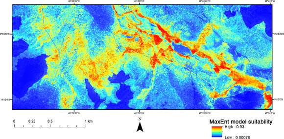
Remote Sensing Helps Map Tool-Wielding Monkeys
Scientists eager to study the bearded capuchin monkeys (Sapajus libidinosus) of northeastern Brazil”especially interesting because they use stone tools to crack open the hard casings of palm nuts to eat the meat inside”are concerned the monkeys will lose critical habitat as industrial agriculture is rapidly expanding and intensifying in the region.

MDA Adds Maritime Imaging Modes for RADARSAT-2
MDA's Information Systems group introduced two new RADARSAT-2 imaging modes for commercial use. The modes are designed specifically for maritime monitoring and are expected to enhance RADARSAT-2 capabilities.
