SAN JOSE, CA, April 20, 2016 - Drone World Expo has announced partnerships with several leading groups whose members are commercial users, or are enabling commercial use of drones including the Air Traffic Control Association (ATCA), American Farm Bureau Federation,...
Topcon and RDO Announce Expansion to GNSS Network Service
LIVERMORE, Calif. – Topcon Positioning Group and RDO Integrated Controls announce an expansion of the TopNETlive GNSS network service across Montana, Wyoming, North Dakota, South Dakota and Minnesota. The increased availability is the result of a cooperative...
Agenda Announced for Drones and Energy Summit, Co-Located at AUVSI’s 2016 XPONENTIAL in New Orleans
New Orleans, Louisiana – UAS Magazine announced this week the preliminary agenda for the UAS Energy In Sight Summit, a one-day event co-located at the world’s largest unmanned vehicle event, AUVSI’s XPONENTIAL. Produced by UAS Magazine, the UAS Energy In Sight...
QGIS 2.14.1 is Now Available
Washington D.C  –  Boundless, the world leader in commercially supported open source GIS software, announces that QGIS 2.14.1, the latest release of the premier open-source desktop GIS technology, is now available for download here. This is a significant...
Trimble Announces Call for Speakers for its 2016 Dimensions User Conference
SUNNYVALE, Calif., April 19, 2016—Trimble (NASDAQ:TRMB) announced today that it is now accepting speaker candidates for Trimble Dimensions 2016 International User Conference being held at a new location in Las Vegas, Nevada—The Venetian, November 7-9, 2016....
Blue Marble to Showcase Global Mapper's UAV Data Processing Capabilities at the AUVSI XPONENTIAL 2016
Hallowell, Maine — Blue Marble Geographics is pleased to announce that it will be exhibiting at the upcoming Association for Unmanned Vehicle Systems International (AUVSI) XPONENTIAL 2016 conference and trade show in New Orleans, LA. This annual event brings...
MobileMapper 300 Now Driven by DigiTerra Explorer v7
Westminster, CO (April 19, 2016) – The MobileMapper 300 smart antenna and DigiTerra Explorer v7, one of Europe’s leading GIS software solutions for mobile mapping, now interface seamlessly. This enables the DigiTerra Explorer to drive the MobileMapper 300...
Boundless Sponsors American Geographical Society's New AGS AP Teachers Fellows Program
Washington D.C — Boundless, the world leader in commercially supported open source GIS software, is proud to announce its sponsorship of the American Geographical Society’s AP Teachers Fellow program. Boundless is providing a grant which will underwrite the...
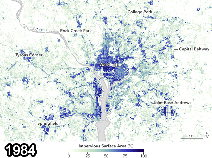
Landsat Data Document Pavement Increase in D.C.
A study recently published in the Remote Sensing of Environment journal used Landsat data from 1984 and 2010 to show how paved surfaces in the Washington, D.C., area have increased dramatically.
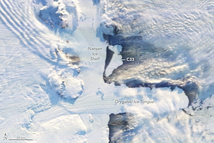
Antarctic Icebergs Break Free
On April 7, 2016, multiple satellites captured the birth of two large icebergs that were shed along a crack on Antarctica's Nansen Ice Shelf during persistent strong offshore winds. The icebergs currently pose no threat to shipping, but they may pose a threat to scientific instruments moored to the seafloor to monitor climate change.
