The 6th Digital Earth Summit, together with a celebration of the tenth anniversary of ISDE, will be held on 7-8 July 2016 in Beijing, China. With the theme of “Digital Earth in the Era of Big Dataâ€, this Summit will offer a great opportunity for scientists,...
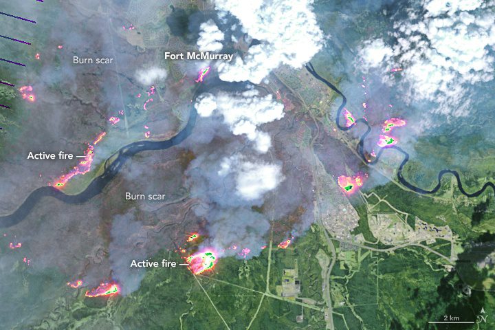
Satellites Monitor Canada's Fort McMurray Wildfire
In early May 2016, a destructive wildfire burned through Canada's Fort McMurray in the Northern Alberta region, forcing the evacuation of more than 80,000 people.
Esri Helps Developers Add Geo to Apps at TechCrunch Disrupt NY 2016
Redlands, California —Today, Esri announced it will be a sponsor and exhibitor at the TechCrunch Disrupt NY 2016 and Hackathon conference to be held in Brooklyn, New York, May 7 to 11, 2016. Esri staff will be on hand to provide information on the free, global Esri...
NASA Selects ASU Undergraduate ‘CubeSat’ Project to Measure Phoenix Urban Heat Islands
NASA has selected an Arizona State University undergraduate student team for a $200,000 grant to conduct hands-on flight research, through its NASA Space Grant Undergraduate Student Instrument Program (USIP). The project, called “Phoenix,†is to design and build a...
Scientist Will Use Satellite Data to Study Lightning That Sizzles
Most cloud-to-ground lightning (about eight of nine events) is actually a rapid series of strikes, pop-pop-pop, each lasting a few hundreds of millionths of a second, too fast for our eyes to separate into individual events. The other one in nine (give or take)...
SpyMeSatGov: Satellite Imagery Mobile App for Government
GREENBELT, MD, May 9, 2016 – Orbit Logic announced today that their SpyMeSatGov iPhone app is now available on the Geoint App Store (https://apps.nga.mil) for any U.S. government or authorized user. SpyMeSatGov provides real-time imaging satellite awareness and...
Earth-i Takes the Best of British to Geospatial World Forum
9th May 2016 — Earth-i (www.earthi.space), the British innovative distributor of Earth Observation and information services, will be supporting this year’s Geospatial World Forum in Rotterdam, The Netherlands, from 23rd to 26th May. The theme of the conference is...
Arithmetica Reveals 360 Imaging and 3D Laser Modeling Tech at Museums and Heritage Show
Shepperton Studios, London, 09 May 2016 – The Museums and Heritage Show, taking place at Olympia, 18-19 May 2016, will feature the latest 360 degree video recording systems and laser scan 3D modeling software from Arithmetica. A specialist in developing ground...
Evolving 3-D Scanning Technology Spurring Big Market Growth, Reports BCC Research
WELLESLEY, MAÂ - Three-dimensional (3-D) scanners have expanded into a wide variety of commercial, scientific and artistic market niches. BCC Research reveals in its new report that key market trends include technology improvements, expanding applications across...
GSDI 15 World Conference: Greg Scott Joins Keynote Speaker Lineup
The organizing team of the 15th Global Spatial Data Infrastructure World Conference (GSDI 15, http://gsdi15.org.tw/) is pleased to announce that Greg Scott will shore up the conference’s already impressive keynote speaker line-up. Mr. Scott will join Mark Reichardt,...
