Countdown to INTERGEO 2016 - For you, this means getting your diary out, studying the conference program and selecting the perfect slots, because the INTERGEO conference will captivate you with the latest hot topics and gripping speakers. Some of the program...
LocationSmart Announces Availability of its Geolocation Platform APIs on Genesys AppFoundry
Carlsbad, CA – LocationSmart®, the worldwide leader in geolocation services for enterprise and consumer applications, has launched its location-based services platform on the Genesys AppFoundry – a newly available online marketplace focused on customer...
GeoDATA 2016 Autumn Series Provides Learning Platform for Geospatial Community
The international GeoDATA 2016 geocommunity Autumn seminar series kicks off in a month’s time. With a strong focus on learning the remaining one day events in Edinburgh, Brussels and London will provide both an informative and a valuable experience for both...
Orbit Logic Adds WorldView-4 to DigitalGlobe Planning Software
GREENBELT, MD – Orbit Logic announced today that it is delivering to DigitalGlobe, Inc. (NYSE: DGI), an updated version of its Direct Access Facility Collection Planning System (DAF CPS) software that includes WorldView-4 and provides multi-user planning...
Countdown to Launch: Lockheed Martin-Built WorldView-4 Imaging Satellite Encapsulated for Sept. 16 Launch
Vandenberg air force Base, Calif. – The WorldView-4 satellite, built by Lockheed Martin (NYSE: LMT) for DigitalGlobe, Inc. (NYSE: DGI), has been encapsulated in its protective launch vehicle fairing. It is scheduled to launch Sept. 16 aboard a United Launch...
Epson Partners with DJI to Create AR Smart Glasses Solutions for Piloting Unmanned Aerial Vehicles (UAVs)
LAS VEGAS - InterDrone 2016 -- Epson, providers of the Moverio® augmented reality (AR) smart eyewear platform, today announced a partnership with DJI, the world's leading maker of unmanned aerial vehicles (UAVs), to create new solutions for the Epson Moverio smart...
Aviation Leaders Harris Corporation and PrecisionHawk Launch LATAS with Live Manned Aircraft Alerts to Help Drone Operators Fly Safer
RALEIGH, N.C. - PrecisionHawk Inc. – a leading provider of aerial data and safety platforms for drones – today announced the launch of its low altitude traffic and airspace safety platform (LATAS). LATAS is the only platform to link drones, 3d ground data and...
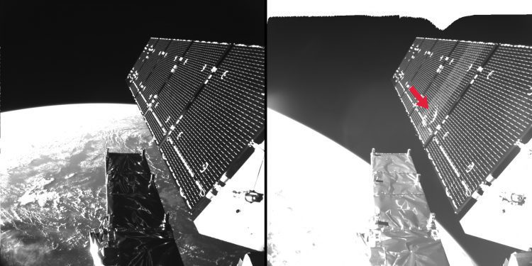
Sentinel Satellite Hit by Space Particle
ESA engineers discovered that a solar panel on the Copernicus Sentinel-1A remote-sensing satellite was hit by a millimeter-sized particle on Aug. 23, 2016.
Timmons Group Redesigns and Implements New Find Wildlife VA Application
The Virginia Department of Game and Inland Fisheries (VDGIF) recently partnered with Timmons Group to redesign and implement the new “Find Wildlife VA†application. VDGIF has distinct users, such as hunters, wildlife viewers, anglers, and boaters that require...
All New KODAK PIXPRO SP360 4K Aerial Pack With Made For SOLO 3DR Drone Mount Ships
LAS VEGAS —   InterDrone 2016 – Paris Hotel, Booth #603 -- JK Imaging Ltd., the worldwide licensee for KODAK PIXPRO Digital Cameras and Devices, today announced its highly anticipated US availability of another groundbreaking and new SP360 4K accessory pack,...
