SAN FRANCISCO — MapD, the market leader in GPU-powered analytics, today announced significant new feature and performance enhancements to its Core database and Immerse visual analytics platform. The new capabilities extend the company's pioneering work in using...
Sentera Partners With RDO Equipment Co. to Offer New UAV Solutions
MINNEAPOLIS -Â Sentera is excited to announce its partnership with RDO Equipment Co., a total solutions provider with 78 stores servicing the agriculture, construction, environmental, surveying, and irrigation industries. This partnership augments the RDO Equipment...
AirMap, DigiCert Introduce First-Ever Digital Identity Certificate for Drones
SANTA MONICA, Calif. — Today, AirMap announced Drone ID, a partnership with DigiCert that will enable, for the first time, instant authentication of an unmanned aircraft's identity via a digital certificate. Drone ID is a major step forward for drone security,...
Geospatial Corporation Positioned to Capitalize on Growing Demand to Accurately Map and Manage the Country’s Outdated Underground Infrastructure
PITTSBURGH-Â Geospatial Corporation (OTCQB Symbol "GSPH") is positioned to capitalize on the growing demand to locate, map and manage the millions of miles of buried energy, water, telecom and electrical pipelines and conduits across the USA. In the last 12 months we...
LizardTech Unveils Lossless Compression of Harris Geiger-Mode LiDAR Data in GeoExpress 9.5.3
SEATTLE, Wash. — LizardTech®, a provider of software solutions for managing and distributing geospatial content, has unveiled lossless compression of Harris Geiger-Mode LiDAR data in the newest release of its GeoExpress software. Users of GeoExpress 9.5.3 can now...
Popular Esri ArcGIS Marketplace App Reaches Milestone With 3,000 Organization Installations
NASHVILLE, Tenn. - GEO Jobe is pleased to announce an important milestone event in the life of our popular Admin Tools for ArcGIS Online. Recently, the popular application designed for Administrators of ArcGIS Online within facilities, government, and organizations,...
Boundless Education Program Expands Support to Promote Geo-Education Everywhere
NEW YORK – Boundless, the leader in open GIS, today announced that it has extended the Boundless Education Program to provide open source GIS software and support for free to educators and students across the globe. "We believe open source software offers...
Ecometrica Makes Deloitte 2016 Technology Fast 500 EMEA
Edinburgh/London, 14 December 2016 - Ecometrica has been named on the prestigious Deloitte 2016 Technology Fast 500â„¢ Europe, the Middle East and Africa (EMEA) list, following a year of rapid growth and important developments for the sustainability software and data...
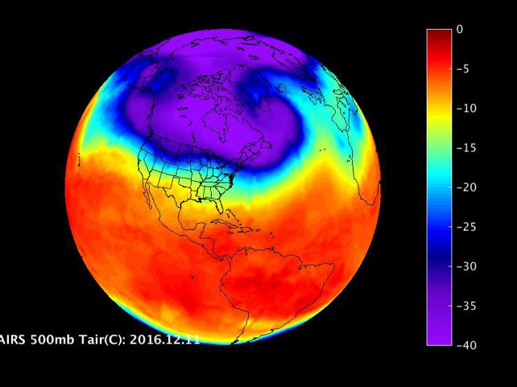
Infrared Imagery Monitors U.S. Cold Snap
Imagery from the Atmospheric Infrared Sounder (AIRS) instrument aboard NASA’s Aqua satellite showed the movement of cold, Arctic air over the United States from Dec. 1-11, 2016.
GerMAP Launches New Aerial Mapping UAV
G170-V, a VTOL (vertical take-off and landing) fixed-wing UAV, is the latest UAV German-based GerMAP has added to the remote sensing and aerial mapping market. G170-V ideally combines the easiness of manual or automatic vertical take-off and landing procedures of...
