SANTA CLARA, Calif. -- Aeris, a pioneer and leader in the Internet of Things (IoT) market, today said it has formed a partnership with MapmyIndia, India’s leader in premium-quality digital maps, global positioning system (GPS) navigation, tracking, location-based...
Swift Navigation Co-Founders Colin Beighley and Fergus Noble Make Forbes 30 Under 30 Consumer Tech List
SAN FRANCISCO, CA - Swift Navigation, the San Francisco-based startup building centimeter-accurate GPS technology that will power a world of autonomous vehicles, is proud to announce that two of its co-founders, Fergus Noble (29) and Colin Beighley (28), have been...
New Technology by Michael Baker International Empowers City of Richmond to Visualize Change and Establish a More Connected Transit System
Michael Baker International, a global leader in engineering, planning and consulting services, is helping residents and city officials in Richmond, Va., rethink the design of the Greater Richmond Transit Company (GRTC) bus system and establish a more connected transit...
Textron’s New iCommand 2.5 Delivers Improved Performance and Scalability
AUSTIN, Texas — Textron Systems Advanced Information Solutions, an operating unit of Textron Systems, a Textron Inc. (NYSE: TXT) business, announced today the release of the new version of its iCommand® integrated command suite, iCommand 2.5. iCommand 2.5...
DigitalGlobe Announces SpaceNet Challenge Results and Plans for Follow-on Competition
DigitalGlobe, Inc. (NYSE: DGI), the global leader in Earth imagery and information about our changing planet, today announced the successful results of the first SpaceNet Challenge and the next phase of the initiative. SpaceNet is a forward-leaning collaboration...
PCI Geomatics Announces Collaboration with Deimos Imaging to Support the PanGeo Alliance
PCI Geomatics, a world leading developer of remote sensing and photogrammetric software and systems, announced today it will be collaborating closely with Deimos Imaging to support the PanGeo Alliance. Deimos Imaging is a founding member of the PanGeo Alliance, which...
LizardTech Receives U.S. Army Certificate of Networthiness for GeoExpress and Express Server Software
SEATTLE, Wash. — LizardTech®, a provider of software solutions for managing and distributing geospatial content, has received Certificates of Networthiness (CoN) for GeoExpress® 9.x and Express Server® 9.x from the U.S. Army Network Enterprise Technology Command...
Long Beach One of First Cities in U.S. to Display Open Data in Geospatial Data Format
Today, the City of Long Beach launched DataLB, the City’s new Open Data Portal. This new portal is designed to implement modern Citywide practices for sharing data with the public, staff, and policy makers as outlined in the Open Data Policy, adopted by the City...
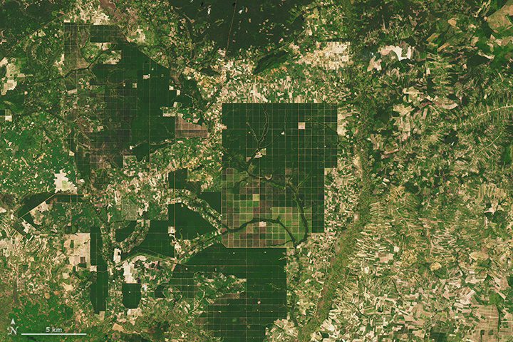
Satellites Chronicle Forest Loss in Cambodia
Between 2001 and 2014, the annual forest loss rate in Cambodia increased by 14.4 percent: a total of 1.44 million hectares”5,560 square miles”of forest. In broad swaths of the country, densely forested landscapes”even those in protected areas”have been clear-cut during the last decade for rubber plantations and timber.
Intergraph Government Solutions Announces Corporate Name Change to Hexagon US Federal
HUNTSVILLE, Ala.—  Intergraph Government Solutions (IGS) today became Hexagon US Federal, a wholly owned subsidiary of Hexagon Safety & Infrastructure serving the U.S. federal government market. The new name allows the company to more closely identify with a...
