US Department of Transportation UAS Integration Pilot Program to lay foundation for nationwide drone operations Airbus Aerial to support UAS IPP teams for Virginia and North Dakota ATLANTA - Airbus Aerial has been selected to provide its domain expertise in unmanned...
Satellite Manufacturing & Launch Markets Finding a New Normal in $250B Opportunity
CAMBRIDGE, Mass.- NSR’s Satellite Manufacturing and Launch Services, 8th Edition report, released today, finds that despite a slow 2017, across the board, the global satellite manufacturing and launch market is poised to generate in excess of $250B in the next...
˜World Class' Ecometrica Platform Wins US Environmental Leader Product of the Year Award for Third Year Running
Scotland/UK – Ecometrica, the downstream space and sustainability company, has won the prestigious US Environmental Leader Product of the Year Award for the third consecutive year for its Ecometrica Platform, which helps business, governments and society to...
Malawi Topographic Mapping, Nautical Charts, Aerial Imagery Now Available from East View Geospatial
MINNEAPOLIS, Minnesota, USA – East View Geospatial (EVG) is pleased to announce that it has expanded its geodata offerings over Africa via a distribution agreement with the Malawi National Spatial Data Centre, Surveys Department. This agreement makes EVG an official...
Teledyne Optech Displays its Advanced Lidar Solutions at GEO Business 2018
Teledyne Optech will display its newest airborne lidar solutions for acquiring accurate geospatial data at GEO Business 2018, London, UK, on May 22-23, 2018. Visitors to booth L28 can discover the wide area mapping features of the Optech Galaxy PRIME and its ability...
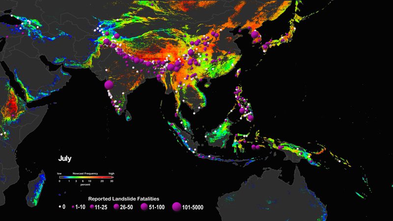
A Near-Real-Time Tool to Characterize Global Landslide Hazards
The Landslide Hazard Assessment for Situational Awareness (LHASA) model melds information regarding slope, lithology, deforested areas, and proximity to fault zones and roads to derive a map of landslide susceptibility.
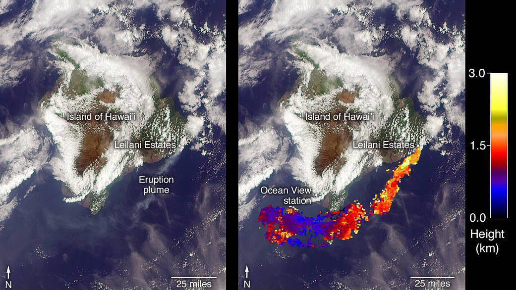
Ash from Kilauea Eruption
On May 3, 2018, a new eruption began at a fissure of the Kilauea volcano on the Island of Hawaii.
Maptitude Team Provides Sponsorship for Applied Geography Conferences
NEWTON MA (USA) - The Applied Geography Conferences (AGC) annual conference will be held October 31 through November 2, 2018, at Kent State University Hotel and Conference Center (Kent, Ohio). AGC exists to promote the application of geographic insights and analysis...
RL10 Engine to Power ULA's New Vulcan Centaur Upper Stage
SACRAMENTO, Calif. - United Launch Alliance (ULA) has selected Aerojet Rocketdyne’s RL10 rocket engine to power the upper stage that will fly atop ULA’s new Vulcan Centaur launch vehicle. The selection came as part of a long-term agreement between the two...
ParaZero Selected as UAS Safety Provider for Multiple UASIPP Teams
ParaZero is pleased to announce that it is a proud member of multiple selected UASIPP teams working on the safe integration of Unmanned Aircraft System (UAS) operations into the National Airspace System (NAS). Â On May 9th, the U.S. Department of Transportation (DOT)...
