LAKE MARY, Fla. - Superion, an industry leader in public sector software solutions, will participate at the Esri User Conference being held July 9-13, 2018, in San Diego, CA. Presenting from conference booth 2119, Superion will showcase Superion Community Development...
Jibestream First Indoor Mapping Platform to Export CAD-friendly Maps
TORONTO - Jibestream, the premier indoor mapping platform provider, announced today the addition of another industry-first feature that allows users to convert and extract indoor maps in a CAD-friendly format. The company’s new map format exchange utility will help...
The World Bank and Singapore Land Authority Sign Memorandum of Understanding (MOU) to promote Greater Use of Geospatial Information and Technology for Sustainable Urban Development
Director for the World Bank Singapore Hub Jyoti Shukla and Singapore Land Authority Chief Executive Tan Boon Khai signed a memorandum of understanding (MOU) today to promote the greater use of geospatial information and technology in support of sustainable urban...
Geosoft Add-in Enhances Integration with ArcGIS Pro
Geosoft has released a new add-in for importing and viewing Geosoft raster files within ArcGIS Pro, Esri’s next-generation desktop GIS.  Geosoft has a long-standing partnership with Esri that’s enabled us to deliver essential workflows for geoscience and GIS...
GAF Introduces Perfect Reference in x, y, z for Orthorectification of VHR Data
Neustrelitz, Germany: As a result of its involvement in the Copernicus activities and the orthorectification of very high resolution (VHR) data for nearly 3.5 million km² of contracted area in the past 3 years, GAF realised there is a need for a consistent reference...
Avineon to Debut Utility Network Accelerators at Esri User Conference
McLean, Virginia – Avineon, Inc. (Avineon), a global provider of information technology and engineering support services, will be presenting its complete portfolio of geospatial offerings at the 2018 Esri User Conference in San Diego, California on July 9-13, 2018...
Orbit GT Will Demo Free ArcOnline Widget for 3D Mapping Cloud at Esri UC, San Diego, CA
Orbit GT will demo the free ArcOnline widget for its 3D Mapping Cloud SaaS platform at next week’s Esri UC in San Diego, CA. “The ArcOnline widget opens a complete new world to all ArcOnline usersâ€, says Peter Bonne, CEO of Orbit GT. “It provides access to...
23 Groups Sign Letter in Support of USGS 3DEP
Reston, VA - Representatives of 23 national organizations have joined together to sign a letter in support of the 3D Elevation Program (3DEP) to newly confirmed USGS Director, Dr. James Reilly. Reilly was nominated by President Trump on January 26,...
Take Your Geospatial Research to the Next Level with MapVault
MINNEAPOLIS, Minnesota, USA – East View Geospatial (EVG) is pleased to offer the latest release of MapVault, a one-of-a-kind streaming service that brings together maps from around the world. MapVault provides access to 500,000+ georeferenced map sheets from over...
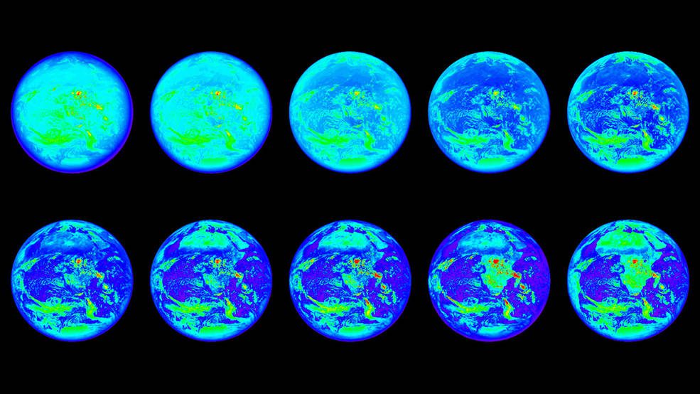
NASA Uses Earth as Laboratory to Study Distant Worlds
A new study uses Earth as a stand-in for an exoplanet, and shows that even with very little light”as little as one pixel”it's still possible to measure key characteristics of distant worlds.
