(Littleton, New Hampshire) CAI Technologies (CAI), a municipal mapping and GIS services company located in Littleton, New Hampshire, is pleased to announce its acquisition of GIS Mapping & Analysis (GISM&A), a Geographic Information Systems (GIS) company...
Small Satellites Flying High with $37 Billion Market and 6,500 Satellites to Launch by 2027
CAMBRIDGE, Mass. - NSR’s Small Satellite Markets, 5th Edition (SSM5), released today, forecasts the market to yield $37 billion in cumulative revenues from smallsat manufacturing and launch services by 2027, with 6,500 smallsats set to launch during this time....
GA-ASI's Certifiable Ground Control Station Makes Its First Flight
SAN DIEGO – A “Certifiable†(STANAG 4671-compliant) Ground Control Station (C-GCS) from General Atomics Aeronautical Systems, Inc. (GA-ASI) was used for the first time on October 4 to fly a Remotely Piloted Aircraft (RPA). The flight originated from Yuma,...
Esri Designates GEO Jobe as a Release Ready Specialty Partner
NASHVILLE, Tenn. - GEO Jobe (www.geo-jobe.com) has been recognized by Esri as a Release Ready Specialty Partner, the latest designation for the Esri Partner Network. Release Ready Specialty signifies GEO Jobe's commitment to keeping pace with Esri technology. The...
Remote GeoSystems Adds MISB Full Motion Video (FMV) Support to LineVision Desktop
FORT COLLINS, Colorado - Remote GeoSystems, Inc., a global provider of immersive geospatial video software and recorders for survey and inspection, is pleased to announce the LineVisionâ„¢ Desktop software suite now supports map-based playback and geoProjectâ„¢...
Orbit GT Releases Version 19 of 3D Mapping Portfolio
“I’m happy to announce that version 19.0 is now available for downloadâ€, says Peter Bonne, CEO of Orbit GT. “Our customers can now immediately take advantage of new features and updates. This release includes all 3D Mapping products and offer a wide range of...
Add Geographic Intelligence to your Software Projects with the Latest Release of the Global Mapper SDK
Hallowell, Maine - Blue Marble Geographics (bluemarblegeo.com) is pleased to announce the immediate availability of version 20 of the Global Mapper Software Development Kit (SDK) along with the accompanying LiDAR Module SDK. Mirroring the most important capabilities...
Technology Demonstrator CIMON* Receives ˜Best of What's New Award' from US Science Magazine Popular Science
Friedrichshafen, 28 November 2018 – CIMON, the technology demonstrator developed and built by Airbus on behalf of the German Space Agency at the German Aerospace Center (Deutsches Zentrum für Luft- und Raumfahrt; DLR) and funded by the German Federal Ministry for...
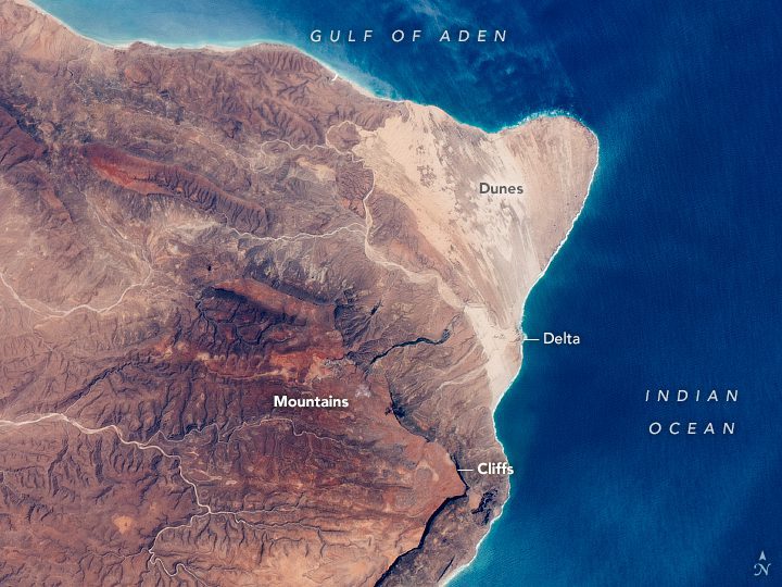
The Horn of Africa, Somalia
An astronaut aboard the International Space Station (ISS) shot this photograph of the Horn of Africa, the easternmost portion of the continent.

NASA Celebrates Mars Landing
On Nov. 26, 2018, Mars received its newest robotic resident. NASA's Interior Exploration using Seismic Investigations, Geodesy and Heat Transport (InSight) lander successfully touched down on the Red Planet after an almost seven-month, 300-million-mile (458-million-kilometer) journey from Earth.
