As part of the Aerial Photography for Great Britain (APGB) contract with the Geospatial Commission Getmapping and Bluesky are providing free at the point of use Web Mapping Services (WMS) for qualifying local government organisations. This allows APGB members, such...
HP Reinvents Print Experiences for Architecture, Engineering and Construction Pros
PALO ALTO, Calif.- Working together just got simpler. Meet HP’s app-based and cloud connected multi-function printer portfolio designed for the architecture, engineering and design community. With seamless set-up and cloud-based connectivity, the portfolio is...
Mapbox and Spatial Networks Announce Partnership to Deliver More Powerful Geospatial Solutions
ST. PETERSBURG, FL & WASHINGTON DC - Spatial Networks, the pioneering geospatial intelligence and technology company, and Mapbox, the leading live location platform for mapping, navigation, visualization and augmented reality, have announced a strategic...
Hemisphere GNSS Announces All-New OEM Positioning & Heading Boards and Next-Generation ASIC Technology
SCOTTSDALE, Ariz.: Hemisphere’s new (Lyra II™) digital ASIC and (Aquila™) wideband RF ASIC designs optimize performance and provide the ability to track and process over 700 channels from all GNSS constellations and signals including GPS, GLONASS, Galileo,...
Ball Aerospace Small Satellite for NASA Arrives in Florida for Launch
BOULDER, Colo., May 20, 2019 — The Ball Aerospace-built small spacecraft for NASA’s Green Propellant Infusion Mission (GPIM) arrived in Florida today to prepare for a June launch on board a SpaceX Falcon Heavy rocket. GPIM is NASA’s first opportunity to...
Airbus signs MOU with Hellenic Space Agency for future space cooperation
London/Athens, 21 May 2019 – Airbus and the Hellenic Space Agency have signed a Memorandum of Understanding (MOU) covering future space cooperation. The MOU will focus on Earth observation, space exploration and future growth opportunities including software...
LORD Corporation Implements the Latest Inertial Sensing Technology on Clearpath Robotics Research Robot Platform
CARY, N.C. — LORD Corporation — a global leader in sensing systems, and Clearpath Robotics, a global leader in mobile robotic platforms, have partnered to bring industry-leading inertial sensors to the Clearpath research robot platform. For precise navigation in...
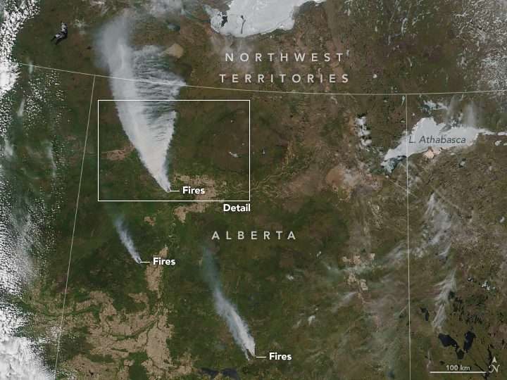
Wildfires Threaten Northern Alberta
Some residents of High Level, Alberta, Canada, were told on May 20, 2019, to evacuate in the face of a large and out-of-control wildfire that has started advancing toward the town.
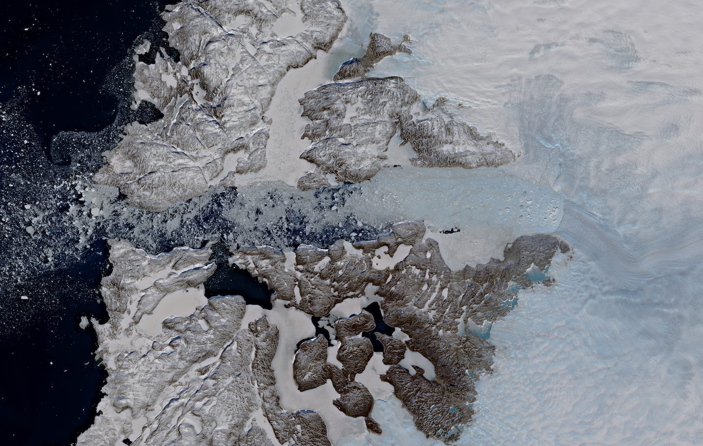
Jakobshavn Glacier
In recent years, Greenland has been losing more ice through the Jakobshavn Glacier than from anywhere else on this huge ice sheet.
Maptitude 2019 Adds Enhanced MapPoint and Streets & Trips Features
NEWTON, MASSACHUSETTS (USA) - Maptitude 2019 dominates the space vacated by MapPoint, supporting Microsoft MapPoint-like tools & queries. With enhanced versions of the features that MapPoint users are familiar with, Maptitude retains the ease-of-use of MapPoint...
