DroneOSSTM Release 4.0. ANRA distinguishes itself from other UTM software platforms by offering one of the most advanced workflow orchestration platform called DroneOSSTM. This software provides an enterprise solution for industries that need to scale and manage...
New Usage-Based Service Plans for Trimble Catalyst Enable Geospatial Organizations to Access Precise Positioning On Demand
SUNNYVALE, Calif. - Trimble (NASDAQ: TRMB) announced today its Trimble® Catalyst™ software-defined Global Navigation Satellite System (GNSS) receiver for Android™ phones and tablets is now available with a usage-based service plan—Trimble Catalyst On Demand....
LIDARUSA Announces Long Endurance Multicopter LIDAR Solution
LiDARUSA is pleased to announce the integration of their UAV-scanning systems with the Harris Aerial H4/H6 Hybrid multicopters. As surveyors and mappers experience growth they assume larger and larger projects making longer flight times increasingly important. The...
Orbital Micro Systems Partners with Georgia Tech for Next-Generation Integrated Radiometer Chip Development
Expertise in silicon-germanium semiconductor chip design will result in reduced size and power usage in radiometer designs Boulder, CO - Orbital Micro Systems (OMS), a leader in advanced instrumentation for small satellite missions and analysis-ready earth data...
Geospatial Intelligence Center and Esri Team Up to Introduce New Tool that Enhances Remote Property Assessments for Insurers
San Diego, Calif. - At the 2019 Esri User Conference, the Geospatial Intelligence Center (GIC), an insurance industry consortium spearheaded by the National Insurance Crime Bureau (NICB), and Esri today introduce Virtual Inspection Studio (VIS). A new tool available...
New Usage-Based Service Plans for Trimble Catalyst Enable Geospatial Organizations to Access Precise Positioning On Demand
SUNNYVALE, Calif.— Trimble (NASDAQ: TRMB) announced today its Trimble® Catalyst™ software-defined Global Navigation Satellite System (GNSS) receiver for Android™ phones and tablets is now available with a usage-based service plan—Trimble Catalyst On...
Woolpert First Provider Approved by PennDOT to Operate Drones for State Projects
The Pennsylvania Department of Transportation requires UAS operators to undergo extensive PennDOT training in addition to attaining the FAA’s Part 107 Remote Pilot Certificate. HARRISBURG, Pa. — Woolpert had numerous surveying, mapping and geospatial professionals...
On-Demand Drone Insurance SkyWatch.AI Launches in UK: The Safer you Fly, the Lower the Premium
Tel Aviv – SkyWatch.AI, the world’s first on-demand, telematics-based insurance platform for commercial drones, today launched in the United Kingdom. Building on its success in the US, SkyWatch.AI’s UK policies will be underwritten by international specialty...

Total Solar Eclipse Darkens the South Pacific
On July 2, 2019, skywatchers in the beach city of La Serena, Chile, looked up at 4:38 p.m. local time to see a black circle in the sky.
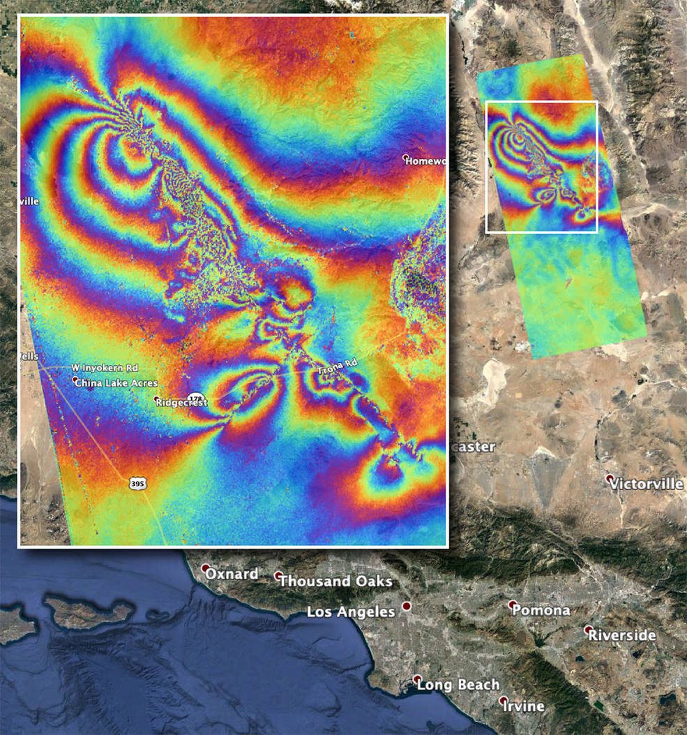
NASA Maps Surface Changes From California Quakes
Damage from two strong earthquakes that rattled Southern California on July 4 and July 5”magnitude 6.4 and 7.1, respectively”can be seen from space.
