“There’s so much Reality Capture performed, generating high quality and high value data. This data is often used for only one project, which is a shame.†says Peter Bonne, CEO of Orbit GT. “The new Marketplace offers simple and direct communication between...
Bluesky launches international MetroVista city mapping service at Intergeo
UK: Aerial mapping company Bluesky is launching their MetroVista city mapping service for Europe at the Intergeo trade fair in Stuttgart, Germany. As the first company in Europe to take delivery of a Leica CityMapper, Bluesky will be showing the MetroVista imagery...
Velodyne Shows Velarray Lidar in Sleek Car Designs at IAA 2019 Conference
SAN JOSE, Calif.- Velodyne Lidar, Inc. (Hall 8.0, Booth A13) is showcasing the pristine integration of Velarray lidar sensors into consumer vehicles to make currently available, high-end electric vehicles safer at the IAA 2019 Conference. Velodyne has addressed the...
Seattle SaaS Startup, Unearth, raises $7 MM in Series A funding to simplify GIS.
Unearth Technologies proudly announces a $7 million Series A investment led by Vulcan Capital, with participation from Madrona Venture Group. This latest round brings the total funding raised by the company to $11.6 MM. Founded in late 2016, Unearth initially focused...
Travelers Uses 3-D Technology from HOVER to Help Make Property Damage Inspections Quicker and Safer
HARTFORD, Conn.- The Travelers Companies, Inc. (NYSE: TRV) today announced it is using HOVER to assist in assessing property damage. HOVER’s technology transforms smartphone photos of any property into an accurate three-dimensional (3-D) model, gathering precise...
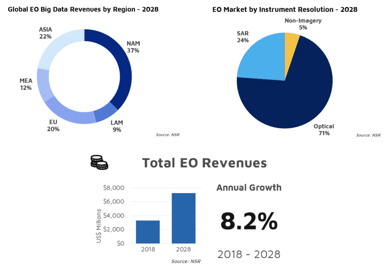
Earth Observation Remains a Satellite Industry Growth Driver
The demand for more data and insights will be driven by upcoming constellations, high-volume data pipelines, and subscriptions for insight services.
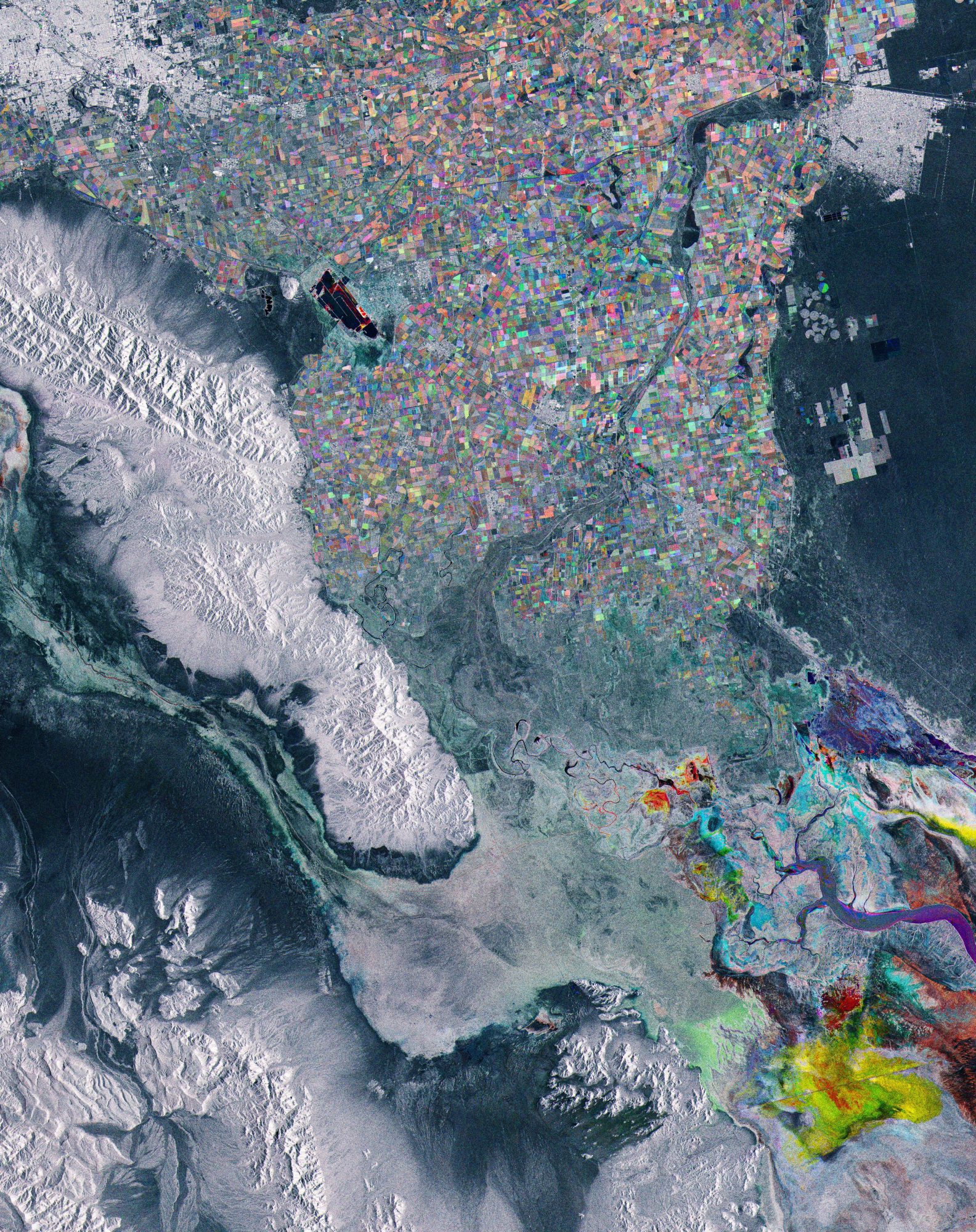
Baja California, Mexico
This Copernicus Sentinel-1 image takes us just south of the U.S. border, to the region of Baja California in northwest Mexico. Its capital city, Mexicali, is visible top left of the image.
Applanix Enhances POSPac Trimble Post-Processed CenterPoint RTX Correction Service to Support High-Accuracy UAV Mapping Without Base Stations
Achieve Centimeter-Level Accuracy Direct Georeferencing Using the POSPac Trimble Post-Processed CenterPoint RTX Correction Service  Stuttgart, Germany, September 17, 2019 - Applanix, a Trimble Company (NASDAQ: TRMB), announced today that the POSPac Trimble...
Trimble 4D Control Software Provides Greater Geotechnical Sensor Support
STUTTGART, Germany, Sept. 17, 2019—Trimble (NASDAQ: TRMB) announced today an update to its core real-time monitoring software—Trimble® 4D Control. Building on the recently released version 5.0, this update delivers support for Senceive’s wireless monitoring...
Trimble Enhances its Indoor Mobile Mapping Solution with New Software for Improved Workflow and Results
STUTTGART, Germany, Sept. 17, 2019—Trimble (NASDAQ: TRMB) introduced today two new software releases designed to further simplify and improve the workflow for indoor mobile mapping, while also improving the final map products that the Trimble® Indoor Mobile Mapping...
