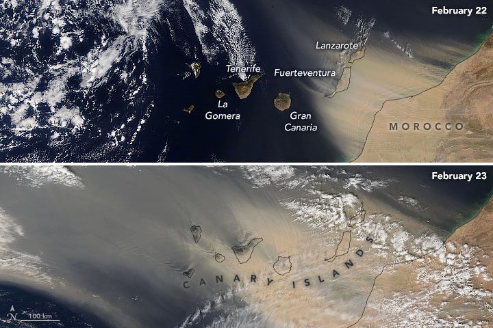
In late February 2020, strong Saharan winds picked up dust from Africa and carried it over the Canary Islands, severely reducing visibility and disrupting travel by land and air.
In late February 2020, strong Saharan winds picked up dust from Africa and carried it over the Canary Islands, severely reducing visibility and disrupting travel by land and air.
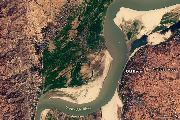
When explorer Marco Polo passed through modern-day Myanmar (Burma) about 700 years ago, one city caught his attention: Bagan.
New product enables collection, correction and confirmation of spatial data in the field Cambridge, UK, 24th February 2020, (www.1spatial.com) 1Spatial, a global expert in Geospatial data, data management and data quality, is pleased to announce an...
Toulouse, 24 February 2020 – The first two Airbus-built Pléiades Neo imaging satellites have started comprehensive environmental testing, to ensure they are ready for in-orbit operation. During the tests, the satellites are subjected to extreme temperatures and...
Cadcorp has developed a visual for Microsoft Power BI, allowing an interactive, user-defined map to be embedded into a Power BI report. The visualization integrates corporate mapping served by Cadcorp SIS WebMap. The user can include their own data overlays to...
Covington, LA – SPOT LLC, a wholly-owned subsidiary of Globalstar, Inc., (NYSE American: GSAT) and a leader in satellite messaging and emergency notification technologies, today announced its newest upgrade. SPOT Mapping is now available for all SPOT devices,...
NEW DELHI & HONG KONG & SEOUL & LONDON & BEIJING & SAN DIEGO & BUENOS AIRES - With the expansion of connectivity, several innovative technologies are becoming more prevalent; location intelligence is one; leveraging location and positioning...
Somerville, AL – February 2017. As a new decade breaks upon us, LIDARUSA is pleased to announce that the Optech CL-360 has joined the ranks of our LIDARUSA Snoopy systems. The Snoopy CL-360 has been meticulously designed for integration on backpack, vehicle, and...
WICHITA, Kan. -Â The FirePoint Innovations Center at Wichita State University today announced six teams have been selected to compete for up to $35,000 in funding in the first-ever FirePoint C3 Challenge. All six will now move forward to the next phase of the...
MGISS, a UK geospatial specialist, has released a new version of its web app TopoGrafi which allows for the display of 3D data in real world models. With enhanced 3D data processing capabilities, TopoGrafi is an end to end platform for capturing buried asset data and...
