AARSCHOT, Belgium – Virtual Surveyor has released Version 7.1 of its popular drone surveying software, introducing functionality to efficiently calculate volumetrics in quarries, mine pits, retention ponds, and other basins that fill with water. This new...
SimActive Speeds Up Stockpile Measurement with Drones
Montreal, Canada – SimActive Inc., a world-leading developer of photogrammetry software, announces an enhanced workflow in Correlator3D™ to accelerate stockpile measurement. The new capability allows to automatically assess multiple volumes within the same...
NAV CANADA signs strategic agreement with Terra Drone's portfolio company Unifly
Unifly is developing a bilingual website and mobile app that would enable drone pilots to identify safe and legal airspace, plan flights, and manage operations Tokyo – Canada’s civil air navigation service provider, NAV CANADA, has entered into an agreement with...
GeoBase Team Wins AFIMSC Team of the Year Award
The AFCEC GIO team is comprised of more than 50 geospatial professionals, most of whom work at Woolpert. JOINT BASE SAN ANTONIO-LACKLAND, Texas — The Air Force Civil Engineer Center (AFCEC) Geospatial Integration Office (GIO) GeoBase team was honored this month...

NASA Selects New Instrument to Continue Key Climate Record
NASA has selected a new space-based instrument as an innovative and cost-effective approach to maintaining the 40-year data record of the balance between the solar radiation entering Earth's atmosphere and the amount absorbed, reflected and emitted
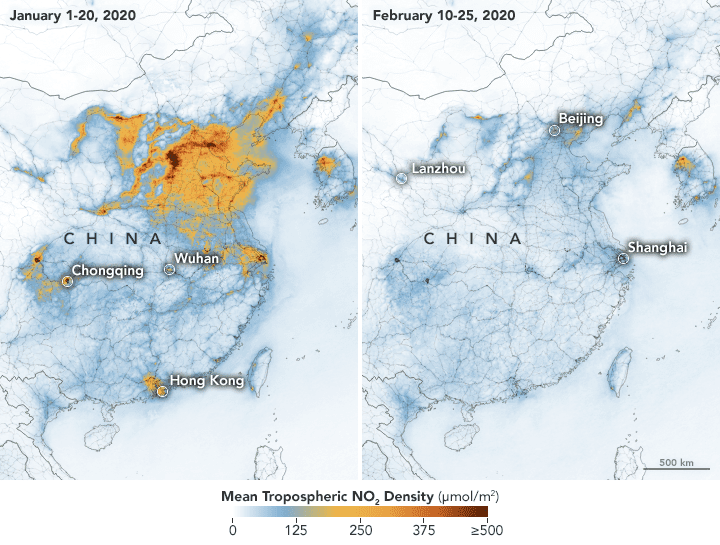
Airborne Nitrogen Dioxide Plummets Over China
NASA and European Space Agency (ESA) pollution monitoring satellites have detected significant decreases in nitrogen dioxide (NO2) over China.
New report identifies key components of authoritative geospatial data
Authoritative geospatial data is one of the basic building blocks for digital transformation and can be defined by seven characteristics that foster its trust across borders and between users, says a new report. Researchers and practitioners in national mapping,...
HERE unveils Geodata Models to lower 5G wireless network planning costs and accelerate deployment
Amsterdam – HERE, a location data and technology platform, today unveiled HERE Geodata Models to help accelerate the telecommunications industry’s planning and deployment of 5G wireless networks while reducing network planning operational expenses. HERE Geodata...
Juniper Systems Limited Expands to India through Partnership with Elkay India
BIRMINGHAM, UK - Juniper Systems Limited, a manufacturer of rugged handheld computers, smartphones, and precision GNSS receivers, today announced its expansion into India via a new partnership with Elkay India. The alliance fills a need in the Indian surveying,...
Kratos Awarded $11.5 Million Contract to Build Advanced Space Radio Monitoring System to Assure Satellite Spectrum
SAN DIEGO - Kratos Defense & Security Solutions, Inc. (Nasdaq: KTOS), a leading National Security Solutions provider, announced today that it was awarded an $11.5 million contract to build an advanced space radio monitoring system for a government customer. The...
