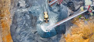
Montreal, Canada “ SimActive Inc., a world-leading developer of photogrammetry software, announces an enhanced workflow in Correlator3Dâ„¢ to accelerate stockpile measurement. The new capability allows to automatically assess multiple volumes within the same project and output comprehensive reports.
If the same area is regularly flown, the new workflow also allows to easily compare volumetric values to assess differences in time. In addition, change detection can be performed to precisely quantity variations in topography.
Facilitating volume calculation reduces the associated costs for our clients, said Louis Simard, CTO at SimActive. Our new workflow is thus a definite advantage for users in multiple industries, including mining, forestry and construction.
About SimActive
SimActive is the developer of Correlator3Dâ„¢ software, a patented end-to-end photogrammetry solution for the generation of high-quality geospatial data from satellite and aerial imagery, including UAVs. Correlator3Dâ„¢ performs aerial triangulation (AT) and produces dense digital surface models (DSM), digital terrain models (DTM), point clouds, orthomosaics, 3D models and vectorized 3D features. Powered by GPU technology and multi-core CPUs, Correlator3Dâ„¢ ensures matchless processing speed to support rapid production of large datasets. SimActive has been selling Correlator3Dâ„¢ to leading mapping firms and government organizations around the world, offering cutting-edge photogrammetry software backed by exceptional customer support. For more information, visit www.simactive.com.
