New senior vice president brings nearly two decades of aviation infrastructure engineering experience to leadership role at firm.  NEW YORK CITY — As aviation professionals navigate the ever-changing and rapidly evolving landscape of their industry, the arrival...
FLIR Launches its First Uncooled, Fixed-Mount, Connected Thermal Camera for Detecting Methane: GF77a
FLIR GF77a Offers Low-Cost Optical Gas Imaging Solution for Continuous and Autonomous Leak Detection ARLINGTON, Va.– FLIR Systems, Inc. (NASDAQ: FLIR) announced today the FLIR GF77a Gas Find IR camera, its first fixed-mount, uncooled, autonomous leak detection...
GSSI to Showcase industry leading GPR systems at ConExpo-Con/Agg Show in March
GSSI, the world’s leading manufacturer of ground penetrating radar (GPR) equipment, will be at the ConExpo-Con/Agg show in Las Vegas, Nevada on March 10-14, 2020. Stop by booth #S64507 in South Hall to see the latest from GSSI for the transportation market and...
Virginia Surveyors Name Dr. Gladys West Honorary Member
The Virginia Association of Surveyors (VAS), the professional society of more than 400 licensed surveyors in the Commonwealth, today announced it has bestowed an Honorary Membership upon Dr. Gladys West of King George in recognition of her work on the mathematical...
Virtual Surveyor Streamlines Volumetric Calculations for Stormwater Retention Ponds, Basins & Quarries
AARSCHOT, Belgium – Virtual Surveyor has released Version 7.1 of its popular drone surveying software, introducing functionality to efficiently calculate volumetrics in quarries, mine pits, retention ponds, and other basins that fill with water. This new...
SimActive Speeds Up Stockpile Measurement with Drones
Montreal, Canada – SimActive Inc., a world-leading developer of photogrammetry software, announces an enhanced workflow in Correlator3D™ to accelerate stockpile measurement. The new capability allows to automatically assess multiple volumes within the same...
NAV CANADA signs strategic agreement with Terra Drone's portfolio company Unifly
Unifly is developing a bilingual website and mobile app that would enable drone pilots to identify safe and legal airspace, plan flights, and manage operations Tokyo – Canada’s civil air navigation service provider, NAV CANADA, has entered into an agreement with...
GeoBase Team Wins AFIMSC Team of the Year Award
The AFCEC GIO team is comprised of more than 50 geospatial professionals, most of whom work at Woolpert. JOINT BASE SAN ANTONIO-LACKLAND, Texas — The Air Force Civil Engineer Center (AFCEC) Geospatial Integration Office (GIO) GeoBase team was honored this month...

NASA Selects New Instrument to Continue Key Climate Record
NASA has selected a new space-based instrument as an innovative and cost-effective approach to maintaining the 40-year data record of the balance between the solar radiation entering Earth's atmosphere and the amount absorbed, reflected and emitted
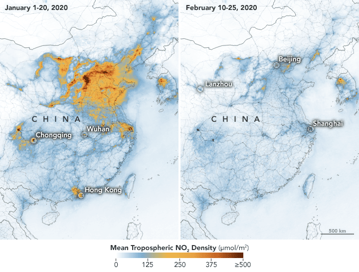
Airborne Nitrogen Dioxide Plummets Over China
NASA and European Space Agency (ESA) pollution monitoring satellites have detected significant decreases in nitrogen dioxide (NO2) over China.
