HUNTSVILLE, Ala. – Atlantic recently purchased a new Phase One Industrial 280MP large-format Aerial Solution to better serve its clients. The upgrade substantially increases Atlantic’s ability to efficiently capture a large area with extreme accuracy and...
GA-ASI Conducts JCG’s Validation Flights in Japan
SAN DIEGO – General Atomics Aeronautical Systems, Inc. (GA-ASI), a global leader in Remotely Piloted Aircraft Systems (RPAS), announced today that they will partner with Asia Air Survey (AAS) to hold a series of validation flights for the Japan Coast Guard (JCG)...
ProStar Joins Trimble's GIS Business Partner Program to Define the Next Generation of Utility Mapping
Trimble GNSS Integrates with PointMan Field Applications to Identify, Capture and Record the Precise Geospatial Location of Utilities SUNNYVALE, Calif.—Trimble (NASDAQ: TRMB) announced today that ProStar has joined Trimble’s GIS Business Partner Program. As...
Cityzenith Unveils New Highly-advanced Digital Twin Technology – SmartWorldPro2
Cityzenith today unveiled its long-awaited Beta release of SmartWorldPro2, the follow-up to its flagship Digital Twin software platform, SmartWorldPro – the go to planning, building and infrastructure tool for city planners and asset managers. Digital Twins are 3D...
Continental Mapping Welcomes Darin David as Director of Commercial Business Development
July 8th, 2020 – Sun Prairie, WI – Industry veteran Darin David has joined Continental Mapping as Director of Commercial Business Development. Mr. David’s experience includes support across federal, state, local, and commercial markets. Mr. David has served in...
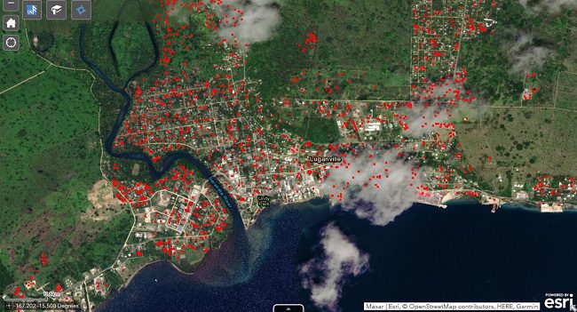
Rapid Mapping Technology to Help Caribbean Through Looming Hurricane Season
Powerful satellite technology can help Caribbean countries better manage natural disasters and boost climate resilience, as the region braces for a busy hurricane season in 2020.
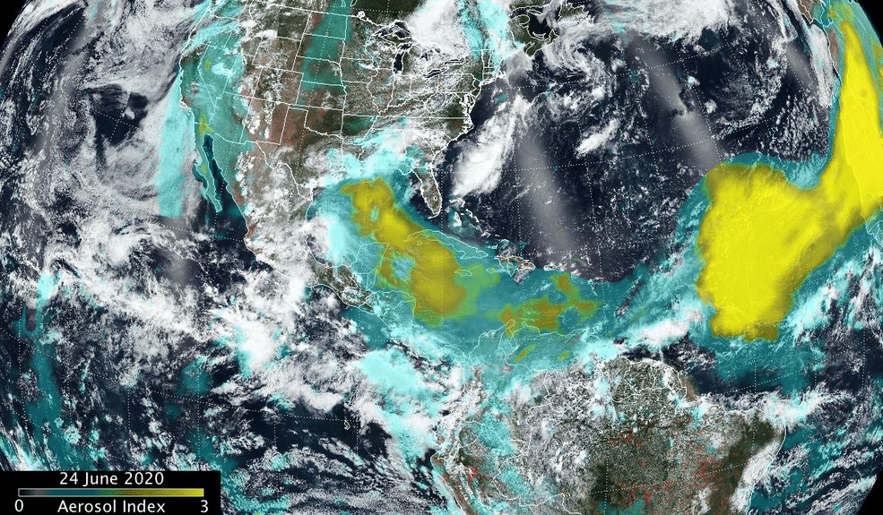
Saharan Dust Aerosol Blanket
NASA-NOAA's Suomi NPP satellite showed the blanket of dust had moved over the Gulf of Mexico and extended into Central America and over part of the eastern Pacific Ocean.
UP42 Adds exactEarth Ship Tracking Data to Geospatial Marketplace
BERLIN, Germany, 7 July 2020 – UP42 today announced that global ship tracking data from exactEarth Ltd. is now offered on the UP42 developer platform and marketplace for Earth observation data and analytics. The exactEarth partnership enables UP42 users to build...
NOAA Selects Woolpert for $40M Shoreline Mapping Support Services Contract
The firm will provide data and technology to support nautical charting, navigation, territorial limits and coastal resources across the country. DAYTON, Ohio (July 7, 2020) — Woolpert has been selected as a prime consultant for the National Oceanic and Atmospheric...
SimActive Software Used for Oil and Gas Seismic Exploration
Montreal, Canada, July 7th, 2020 – SimActive Inc., a world-leading developer of photogrammetry software, announces that its Correlator3D™ product is being used by Texas-based company Dawson Geophysical for oil and gas seismic exploration.  Orthomosaics and...
