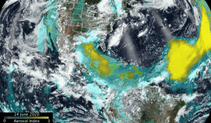
 Dust storms from Africa's Saharan Desert traveling across the Atlantic Ocean are nothing new, but the current dust storm has been quite expansive and NASA satellites have provided a look at the massive June plume. NASA-NOAA's Suomi NPP satellite showed the blanket of dust had moved over the Gulf of Mexico and extended into Central America and over part of the eastern Pacific Ocean.
NASA uses satellites and other resources to track aerosol particles made of desert dust, smoke and volcanic ash. The Visible Infrared Imaging Radiometer Suite (VIIRS) instrument aboard Suomi NPP provided a visible image while the Ozone Mapping and Profiling Suite (OMPS) Nadir-Mapper (NM) instrument aboard the Suomi-NPP satellite provided absorbing aerosol index values. The OMPS index indicates the presence of light absorbing aerosol particles (ultraviolet (UV)-absorbing particles in the air) such as desert dust. The absorbing aerosol index is related to both the thickness and height of the aerosol layer.
The accompanying image is a composite of the OMPS aerosol index and the VIIRS visible image both from NASA/NOAA's Suomi NPP satellite on June 24, 2020. The image shows the dust plume moved over the Yucatan Peninsula and up through the Gulf of Mexico.
Image Credit: NASA/NOAA, Colin Seftor

