REDLANDS, Calif.— Esri, the global leader in spatial analytics, today announced the publication of GIS Tutorial for Crime Analysis, second edition. Readers use Esri ArcGIS software and sample data as they work through step-by-step exercises and independent...
Map of the Month: Fashion's share of retail turnover, Europe 2017
The fashion segment enjoyed a 13.5% share of the EU-28's total stationary retail turnover in 2017. According to GfK's recent study on European retail, stationary retail and particularly fashion retail are under pressure from e-commerce, off-price concepts, vertically...
Stationary Retail in Europe to Grow by 2.1 Percent in 2018
Bruchsal, Germany, May 22, 2018 – GfK anticipates a 2018 nominal turnover growth of +2.1 percent for stationary retail in the 28 EU member states. But trends within the individual countries under review vary widely. While real-value growth is expected for...
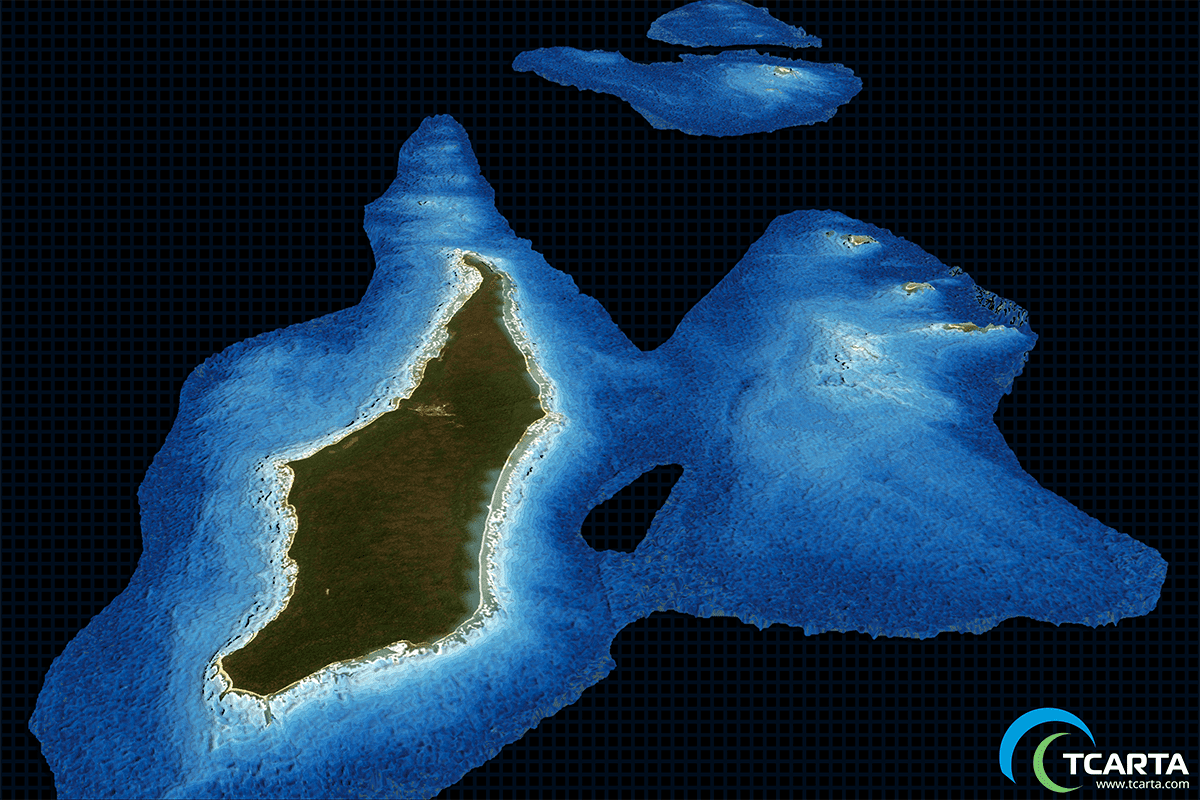
Satellite-Derived Bathymetry Data Aids Hydrocarbon Exploration
TCarta delivered satellite-derived bathymetry (SDB) to Total SA, one of the world's largest oil and gas producers, which will use the water-depth data for preparing seismic survey works off the coast of Myanmar.
TerraGo Launches New Mobile Application in NGA GEOINT App Store
TerraGo, a leading provider of dissemination and collaboration software for defense and intelligence agencies, announced today the availability of R3, a mobile data collection and collaboration app customized for the missions of reconnaissance, response and recovery....
Boundless Introduces New Lightweight, Portable, Offline Basemap Server
St. Louis, MO – May 22, 2018 – Boundless, the leader in open and scalable GIS, today introduced Boundless Offline Tile ServerTM, a lightweight, portable, purpose-built map tile server that provides detailed global basemaps on demand while offline. With this...
Skyline Software Systems Releases PhotoMeshâ„¢ v7.4 with LiDAR Integration and Improved Aerial Triangulation Capability
Herndon, VA – Skyline Software Systems Inc. announced today that it has released PhotoMesh™ v7.4 software suite as part of its SkylineGlobe products. This update integrates light detection and ranging (LiDAR) data, significantly improves processing speed and...
Swift ‹‹Navigation ‹‹Announces SBAS Support for ‹‹Piksi Multi
San Francisco, CA — Swift Navigation, ​​a ​​San ​​Francisco-based ​​tech ​​firm that is building centimeter-accurate ​​GPS ​​technology ​​to ​​power ​​a ​​world ​​of ​​autonomous ​​vehicles, ​​today...
American Geographical Society to Award Samuel Finley Breese Morse Medal to Dr. Christopher Baruth
The Samuel Finley Breese Morse Medal, awarded by the American Geographical Society (AGS), is one of several prestigious honors given by the Society. Dr. Christopher Baruth, former Curator of the American Geographical Society Library (AGSL), will receive the medal...
MAPSâ„¢ SLs Emulator for Simulation of Location Based Services in LTE Network
GAITHERSBURG, Md. - GL Communications Inc., a global leader in telecom test and measurement solutions, today announced its enhanced Location Services (LCS) architecture in LTE network briefly, and its latest MAPSâ„¢ SLs Emulator solution to meet the requirements in...
