December 2, 2015 — A newly published, three-volume “Remote Sensing Handbook†is a comprehensive coverage of all remote sensing topics written by over 300 leading global experts. With 82 chapters, and more than 2000 pages, the handbook is a reference for every...
USGS Projects Large Loss of Alaska Permafrost by 2100
December 1, 2015 — Using statistically modeled maps drawn from satellite data and other sources, U.S. Geological Survey scientists have projected that the near-surface permafrost that presently underlies 38 percent of boreal and arctic Alaska would be reduced by 16...
US Topo Maps Reach Milestone
November 19, 2015 — With the release of new US Topo maps for Illinois and South Dakota, the USGS has completed the second, three-year cycle of revising and updating electronic US Topo quadrangles. This means that since late 2009, the USGS has published nearly every...
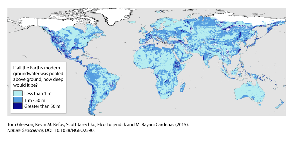
Study Maps Earth's Hidden Groundwater
An international group of hydrologists produced the first data-driven estimate of Earth's total supply of groundwater.
Free Data Proves Its Worth for Observing Earth
November 16, 2015 — Since late 2008, when Landsat earth observation images were made available to all users free of charge, nearly 30 million Landsat scenes have been downloaded through the U.S. Geological Survey portal – and the rate of downloads is still...
Newly Released Photo Catalog Puts US Landscapes On Exhibit
November 10, 2015 — The U.S. Geological Survey announced today that it has made part of a huge national repository of geographically referenced USGS field photographs publicly available. USGS geographers developed a simple, easy-to-use mapping portal called the Land...
Getting Recognized for Volunteer Mapping Efforts
October 28, 2015 — Volunteers are being recognized and earning custom badges for making significant contributions to the U.S. Geological Survey's ability to provide accurate and timely information to the public.  Using crowdsourcing techniques, the USGS project...
USGS Maps Human-Induced Land Changes
The U.S. Geological Survey released a Landsat-based report and dataset on anthropogenic land-use trends in the United States from 1974-2012. The time periods coincide with U.S. Department of Agriculture (USDA) Census of Agriculture data-collection years.
New Elevation for Nation's Highest Peak
A new, official height for Denali has been measured at 20,310 feet, just 10 feet less than the previous elevation of 20,320 feet which was established using 1950’s era technology. With this slightly lower elevation, has the tallest mountain in North America shrunk?...
Woolpert Selected by USGS to Evaluate New Lidar Technologies for 3DEP
DENVER, August, 13, 2015 — The U.S. Geological Survey (USGS) has contracted with Woolpert to evaluate new lidar (light detection and ranging) technologies to assess the suitability to support the 3D Elevation Program (3DEP). This use of the single photon and Geiger...
