Sunriver, Oregon, July 16, 2015 — MAPPS, the national association of private sector geospatial firms, announced today the slate of new officers and members of its 2015-2016 Board of Directors. Susan Marlow, GISP, Principal with Stantec (Nashville, TN), assumed the...
Updated Pan-European Datasets Released by EuroGeographics
July 15, 2015 — Two updated pan-European datasets created from authoritative national datasets have been released by EuroGeographics. EuroBoundaryMap, a seamless geo-database at 1:100 000 scale, and EuroRegionalMap, a 1:250 000 scale topo-geographic dataset, have...
OGC Invites Organizations to Co-sponsor a Major Spatial Interoperability Testbed
July 13, 2015 — The Open Geospatial Consortium (OGC®) invites organizations with specific spatial data integration requirements to explore a low cost, highly effective, high return on investment testbed approach to meeting those requirements. OGC testbeds are rapid...
Avineon to Demo Geospatial Services at Esri User Conference
McLean, Virginia, July 8, 2015 — Avineon, Inc. (Avineon), a global provider of information technology and engineering support services, will be presenting its complete portfolio of geospatial offerings at the 2015 Esri User Conference in San Diego, California on...
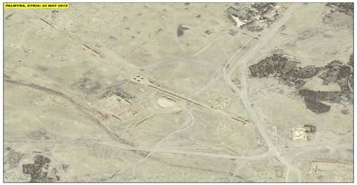
UNESCO and UNITAR-UNOSAT Protect Cultural Heritage with Geospatial Technologies
At the annual meeting of the World Heritage Committee in Bonn, Germany, UNESCO and UNITAR (the UN Institute for Training and Research) signed an agreement to protect cultural and natural heritage sites with the latest geospatial technologies. The strategic partnership will enable the organizations to work together during conflict situations and following natural disasters, sharing their respective expertise, and collaborating on prevention and capacity development.
CBP Agent Geoffrey Krassy Honored with Lt. Michael P. Murphy Award
Washington, D.C., June 24, 2015 —This afternoon at the United States Geospatial Intelligence Foundation’s (USGIF) GEOINT 2015 Symposium, the 2015 Lt. Michael P. Murphy Award in Geospatial Intelligence was presented to Geoffrey D. Krassy, an air interdiction agent...
OGC Seeks Public Comment on SensorThings API Standard for Internet of Things
June 19, 2015 — The OGC® membership seeks public comment on the candidate OGC SensorThings API Standard, Part 1. The OGC SensorThings API is a free and non-proprietary lightweight interface specification that simplifies and accelerates the development of Web-based...
ENVITIA receives contract from HP to deliver Defence Geospatial Services (DGS) contract to the UK Ministry of Defence
June 11, 2015 — ENVITIA has been awarded a contract by Hewlett Packard Enterprise Services UK to deliver, in partnership, the first phase of the Defence Geospatial Services (DGS) programme to the UK Ministry of Defence. DGS will provide a step change to the...
exactEarth and Harris Corporation Form Strategic Alliance to Provide Real-Time Global Maritime Tracking and Information Solutions
Cambridge, ON – June 8 , 2015 — exactEarth Ltd., the leading provider of Satellite Automatic Identification System (AIS) data services and Harris Corporation (NYSE:HRS), a world leader in space, geospatial and remote sensing solutions, have formed an alliance to...
Paul Scarponcini Receives OGC's Gardels Award
June 5, 2015 — At the June meeting of the Open Geospatial Consortium (OGC(R)) Technical Committee in Boulder, Colorado, USA, Paul Scarponcini, PE, PhD received the OGC's prestigious Kenneth D. Gardels Award (http://www.opengeospatial.org/ogc/awards). Carl Reed,...
