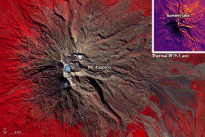
On April 20, 2016, ASTER captured this false-color image of Mount Ruapehu, with vegetation as red, the crater lake as light blue and rock as brown. The inset, made with observations of thermal infrared energy, shows warmer areas in yellow and cooler temperatures in purple. (Credit: NASA Earth Observatory image by Jesse Allen, using data from NASA/GSFC/METI/ERSDAC/JAROS, and U.S./Japan ASTER Science Team)
Mount Ruapehu is a 2,797-meter (9,177-foot) peak on New Zealand's North Island that's popular with skiers and snowboarders and other outdoor adventurers. One of the most-active volcanos in New Zealand, major eruptions occur approximately every 50 years, most recently in 1895, 1945 and 1995.
In 1953, a natural dam on the edge of the crater lake gave way, sending a river of liquefied ash and mud (lahar) rushing into the Whangaehu River. That event destroyed a railroad bridge, sent an oncoming train crashing into the river, and took the lives of 151 people.
The threat of lahars, combined with the large numbers of people regularly using the mountain, prompted geologists to monitor Ruapehu for signs of unrest. From space, the Advanced Spaceborne Thermal Emission and Reflection Radiometer (ASTER) on NASA's Terra satellite can detect thermal infrared wavelengths and be used to observe volcanos on the verge of erupting.
In April 2016, the temperature of Ruapehu's crater lake increased from 20 to 45 degrees Celsius (68 to 113 degrees Fahrenheit). As of June 3, 2016, local authorities listed the volcanic alert at level 2, indicating moderate to heightened volcanic unrest.

