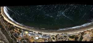
An AVIRIS-NG red-green-blue (visible) aerial image of the Refugio Incident oil spill shows oil on the water and on nearby Santa Barbara Channel beaches. (Credit: NASA/JPL-Caltech)
On May 19, 2015, an on-land pipeline ruptured north of Santa Barbara, Calif., spilling 105,000 barrels of crude oil onto Refugio State Beach and about 21,000 gallons of oil into the Pacific Ocean in the north Santa Barbara Channel.
In response to the Refugio Incident, NASA deployed a De Havilland Twin Otter aircraft carrying a unique airborne instrument developed by NASA's Jet Propulsion Laboratory to study the spill and test the ability of imaging spectroscopy to map tar on area beaches.
The JPL-built Airborne Visible Infrared Imaging Spectrometer, Next Generation (AVIRIS-NG) instrument uses spectroscopic measurement of energy reflected from Earth's surface to determine surface properties. In this case, AVIRIS-NG focused on applying imaging spectroscopy to accurately map the presence of oil-derived tar balls on the beaches, using direct, on-the-ground observations to verify the remote-sensing data. AVIRIS-NG can capture spectral imagery that's commonly used to map ecosystems, minerals, land use and trace gases.
To support the AVIRIS-NG overflights of the larger region, the team deployed to a beach affected by tar from the spill to map beach tar and collect surface spectra, assisted by citizen scientists. They mapped a 220-foot (67-meter) span of the beach in detail, noting locations and coverage of tar on the beach. AVIRIS-NG then flew over the beach. Tar was detected successfully in the AVIRIS-NG spectral data, validating the effectiveness of this advanced remote-measurement technique. The beach tar map was subsequently forwarded to the Incident Command for the Refugio Incident and was incorporated into the response's daily shoreline cleanup and assessment technique.

