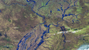
A false-color NOAA Suomi NPP VIIRS satellite image documents flooding in the Mississippi River Valley on Jan. 3, 2016. (Credit: NOAA/NASA)
The Mississippi River Valley has been experiencing record floods after a series of storms brought heavy rains to the region in late December 2015. The torrential rainfall pushed some parts of the Mississippi River and its tributaries to record-high levels, particularly for the time of year.
Due to the wide and flat nature of the Mississippi River Valley, floods take longer to develop and recede. It can take weeks for floodwaters to move completely through the system.
The National Oceanic and Atmospheric Administration (NOAA) used its Suomi NPP VIIRS high-resolution imagery channels to provide highly detailed flood maps to area responders, using a newly developed algorithm to detect standing water. Such imagery can be seen by the Space Science Engineering Center, which partners with NOAA to develop many advanced satellite products, in a new mapping tool called RealEarth.

