When commodity markets are fragile, it's important for companies, banks and countries to understand how the supply and prices of natural resources are affected by local and global conditions.
It's vital for such organizations to answer important and numerous questions, including the following possibilities:
- How do floods affect livestock production in Southeast Asia?
- Do monsoonal rains provide a bumper rice harvest?
- Will drought in Australia influence vegetable production?
- Is the water supply in the local dams enough to allow irrigation of citrus fruit this summer?
For many years, satellite-based Earth observation has been used to help provide these answers, and there are numerous examples of remote monitoring in the many dedicated journals and conference presentations.
However, some aspects of the supply of natural resources often are overlooked when talking about monitoring. Collection, transport, storage and distribution all are essential steps in the supply chain, and Earth observation can play a vital role in all. Supply routes, stockpiles, congested transport routes and the existence of empty or full storage facilities all can be monitored remotely.
These extended applications require high-quality data with sufficient spatial detail, availability and affordable acquisition.
Information Doors
With these criteria in place, remote sensing could be used to detect any environmental issues that may develop around a working port and then use the information to alert interested parties that the facility may not be able to operate at full capacity if the situation continues to deteriorate. This would allow the port to continue operating while changes are made to avoid closure.

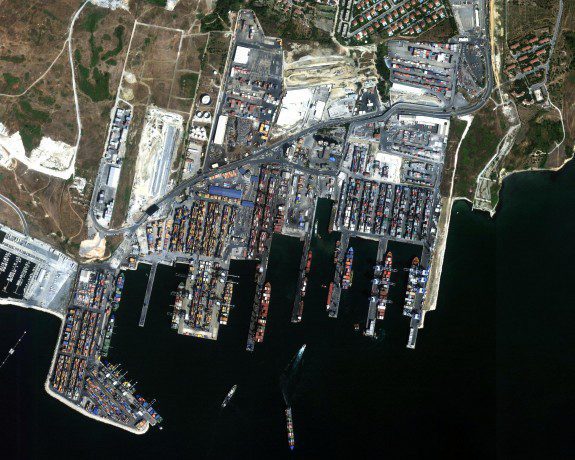
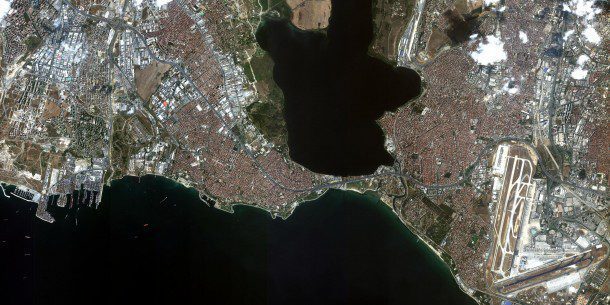
A satellite image (top) shows Istanbul, Turkey, with Ataturk International airport on the right and a sea-freight terminal on the left. A zoomed-in image of the freight terminal (bottom) shows boats waiting to unload, which can be used to lessen delays in unloading and delivery of goods.
Such continuous monitoring uses intelligence gathering in different and creative ways. Rather than relying on people on the ground delivering subjective news”everyone can make objective observations”authoritative information can be used to support decisions and be kept for future reference.
Advances in high-spatial-resolution satellite technology have opened information doors only feasible in science-fiction novels just a few years ago. It has even created concerns among big corporations that the information delivered by high-resolution satellites is too good for their comfort. This creates an environment where companies feel compelled to keep up with such technology to not fall behind and give up any market advantage.
Cost Effective?
But is such monitoring via satellite technology a cost-effective method? It all comes down to quality, availability, effectiveness and price for the appropriate type of satellite data. If one wants to undertake natural-resource monitoring, high-spatial-resolution optical data generally are required, but such data aren't freely available”they come at a cost.
Fortunately, the cost of high-quality data is becoming competitive; although one coffee farmer in Africa may not be able to afford such data, the company buying and distributing the end product in Europe may forge a market advantage with such information.
With data costs well under $20 per square kilometer for medium-sized areas of interest, even a repeated monitoring effort seems cost effective in comparison to not doing it.
Verifying stockpile volumes of iron ore or coal in regular intervals provides the confidence of supply chains not being interrupted on a production site. Monitoring transport routes, whether rail, road or shipping, informs about the timely delivery of the commodities, possibly noticing a potential under or over supply.
In addition, storage facilities have limited capacities. Are they full? Are new ones being built? Are expected deliveries diverted to other off-loading facilities? Many pieces of information can be derived from such information, supported by high-resolution optical satellite data.
The accompanying satellite images show recent examples of infrastructure monitoring in Istanbul, Turkey, and demonstrate some of the detail available in high-resolution satellite data. Goods worth millions of dollars are moved in and out from here every day, so smooth operations are important to businesses using the infrastructure. Such data can derive information for value-added products and educated business decisions.
Peter Hausknecht is chief scientist, Earth-i Ltd.; e-mail: [email protected].


