 By Matt Ball
Mexico is among the ambitious countries that committed to the Tier 3 requirements of the Reduce Emissions from Deforestation and Degradation (REDD+) international conservation mechanism. At all tiers, REDD+ involves estimating carbon stocks in forests as well as management practices that improve a forest's carbon-carrying capacity.
At higher-tier levels, the methodology, monitoring and modeling are informed by increasingly accurate high-resolution activity data that quantify forest activities to ensure improvements. At Tier 3, the requirement is for yearly insight down to half a hectare or better.
With international funding from the government of Norway and support from the Food and Agriculture Organization as well as the United Nations Development Programme, Mexico established a world-class remote-sensing operation to monitor forest change. The National Commission for Knowledge and Use of Biodiversity (CONABIO) is the applied-research institute that generates information and operates several systems to collect and share details at a countrywide scale to comply with the annual REDD+ reporting requirements.


The REDD+ satellite-based land cover monitoring system of Mexico features countrywide data collection for land cover and land cover change. There are 135 distinct Landsat tiles for the country versus 4,000 distinct RapidEye tiles.
Measuring and Reporting
Mexico's National Forest Monitoring System was established to provide the systematic long-term monitoring of forests and other land use as well as assess and compare the historical and projected rates of deforestation and degradation. The country's forests make up nearly 40 percent of its nearly 2 million square kilometers of land cover. Deforestation rates of nearly 500,000 hectares per year have been documented from 1993-2007, and the country is working to combat this trend.
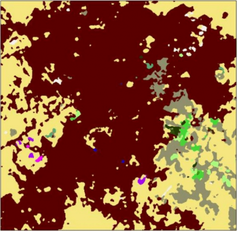
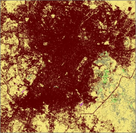
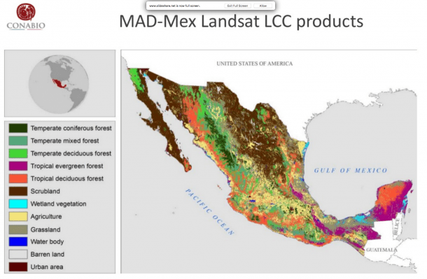
The REDD+ satellite-based monitoring system focuses on automatic land-cover classification, and CONABIO uses Landsat and RapidEye data to create national land-cover products. Landsat data were used to create seven historical national land-cover maps at a scale of 1:100,000 between nine and 35 land-cover classes. RapidEye data provide the means for national land-cover products at a scale of 1:20,000. Products derived from the imagery classify land cover and land-cover change, forest and non-forest areas, and forest change.
It's important to note that automatic satellite-image classification is a key requirement to provide timely products in a standardized and cost-effective manner at a country scale.
Mexico has to report on a yearly basis about deforestation and degradation of their forests, says Rainer Andreas Ressl, CONABIO's director general, Geomatics. Currently, there is no technology available to do that reporting outside of what we are developing here on the basis of RapidEye data.
Constant Coverage
CONABIO uses imagery from MODIS, SPOT and RapidEye to monitor forests and land change. Planet Labs' five-satellite RapidEye constellation currently is the only satellite imagery CONABIO has found with the capacity to meet its yearly cloud-free monitoring requirements.
RapidEye provides two almost cloudless countrywide coverages per year for dry and wet seasons, says Ressl. Using dry-season images is typical in the tropics, because they are more likely to be cloud free. However, you don't capture changes in dry forests and sparse bush vegetation. Missing the foliage of the wet season would result in a large underestimation of carbon within the Mexican REDD+ initiative.
RapidEye satellites collect 6 million square kilometers per day, measuring reflectance across five spectral bands. The red-edge and near-infrared bands allow for semi-automated analysis of vegetation types and stressors to determine the health of crops and forests.
One important characteristic of our RapidEye images is the red-edge band that improves the classification and feature selection over agriculture and forest areas, says Andres Castillo, Planet Labs' regional sales director for Latin America. Using our imagery, CONABIO built a land-coverage map of the entire country at a scale of 1:20,000 with more than 45 different land-cover classifications.

The Landsat data generates countrywide land cover maps at a scale of 1:100,00 with 9 land-cover classes. The RapidEye data generates maps of 1:20,000 with more than 45 land-cover classes.
Making a Mosaic
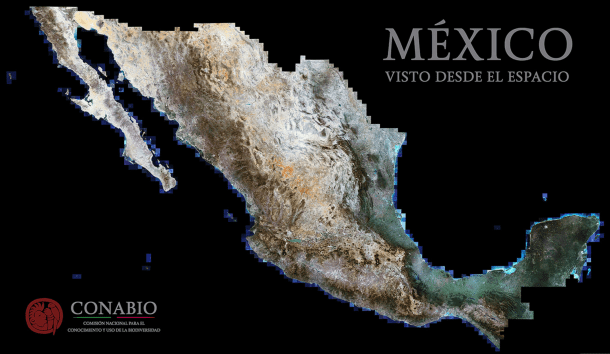
The countrywide data coverage provides a useful baseline reference for many ongoing monitoring and mapping efforts. To help reinforce this countrywide collect, CONABIO set out to create a complete country mosaic of imagery. With a spatial resolution of five meters, the new mosaic adds greater accuracy than what was built more than 10 years ago from Moderate Resolution Imaging Spectroradiometer (MODIS) imagery with a spatial resolution of 250 meters.
We applied script-based filtering to find the most-suitable scenes from the archive in terms of cloud coverage, says Florian Hruby, visualization specialist in CONABIO's Geomatics department. We started with a total of 50,000 RapidEye scenes and reduced those to 25,000 dry-season images. Then, with Python code we ran on the RapidEye metadata, we reduced the number to 4,300 best scenes that have been integrated into the mosaic.
CONABIO used PCI Geomatics' GXL large-volume image-production system to select, process and orthomosaic images while performing quality-assurance functions such as reducing the effects of haze and clouds, and balancing radiometric differences. The software also balances the radiometric differences between overlapping scenes for a consistent and seamless imagery product.
PCI Geomatics' Geomatica software also helped edit and fine-tune each image. The Smart GeoFill tool proved helpful, aiding the selection of areas needing replacement due to clouds or cloud shadows and replacement with better image clips from the archive via micro mosaicking.
It was an iterative process to get the least amount of clouds and also get a temporally and radiometrically homogeneous dataset, says Hruby. We haven't yet published the final dataset for distribution, but it will be at least one terabyte of data”even larger if we include the ocean areas. In contrast, the MODIS mosaic was one to two gigabytes of data, which was a challenge with the technology we had in 2003. There is almost no limitation with today's software and cloud computing that can handle very large datasets.
Baseline Benefits
The MODIS mosaic created in 2003 had a major impact, including use by the Ministry of Education for thematic maps distributed in public schools throughout the country. The new mosaic will be used for similar thematic maps of biodiversity and ecosystems, but at a much higher resolution.
We are going to visualize deforestation of certain ecosystems, such as mangroves in the coastal areas, notes Ressl. The RapidEye mosaic is going to provide good reference information for a lot of environmental studies.
Currently, CONABIO produces a national inventory of mangroves, and it's committed to repeat that exercise every five years. Mangroves provide the nurseries of the ocean with habitat and nourishment for the reproduction of many marine species. They also act as protective barriers against hurricanes and flooding.
CONABIO used this imagery to classify and quantify the extent and degradation areas of mangroves, and it will use the data as a baseline to manage their health as well as identify and combat forces leading to their destruction.
CONABIO also is looking at the imagery for wetland studies to see the dynamics of wetlands through time. Availability of RapidEye imagery for dry and wet seasons provides the maximum dynamic of the wetland through time. The availability of data over many years allows researchers to describe how wetlands fluctuate through the seasons.
Although the data are informing environmental-monitoring functions, they also help with overall operations. CONABIO is looking into using this high-accuracy mosaic to generate an imagery-chip database that could be used to automatically georeference other data sources to improve their accuracy.
We have Spot 5 and Spot 6 data, and there is a huge national data archive here, adds Ressl. Unfortunately, the georeferenced accuracy of the data is not very high. Sometimes you have offsets of up to 200 meters, which make it difficult to use for thematic applications.
Mexico only has a 30-meter digital elevation model, and the georeferencing issue is particularly pronounced in mountain regions. Use of the chip database to recognize and align current and historical imagery could unlock further insights, as every image in the older SPOT archive currently must be georeferenced.
Dedicated to Distribution
The image mosaic isn't intended primarily as an analytical dataset, rather as an overall reference and mapping product that can be built upon. The mosaic data have been reduced from 16- to 8-bit, and a global histogram was applied to make it as visually attractive as possible. The visual impact of the countrywide image is stunning, and it's being promoted and displayed as a technical achievement as well as a source of national awareness and pride.
We have a large printout on the side of the building that is 16 by nine meters, says Ressl. We are thinking about printing it larger for the COP 13 meeting and making it walkable, so people could walk over the mosaic and see down to the block level. This would help make satellite imagery and derived information more understandable and accessible.
CONABIO also has plans to distribute the mosaic through its geoportal, where it already distributes imagery and data products, including more than 5,000 maps.
We want to use the mosaic as baseline information for Web-mapping services that are similar to what Google does, but with our own database and data sources, adds Ressl. We want to make data more easily accessible and understandable for users in general, but for decision makers in particular, through geovisualization with 3D and 4D visualization.
Ongoing work still is being done to polish coastal areas to provide a seamless and equalized product for coastal and terrestrial locations. When the polishing phase is complete, the data will be published, and more work will be done to make the mosaic digestible for all users.
Broadening Insights
CONABIO also is examining next steps to use high-resolution texture information from the RapidEye mosaic for overflights and exploring areas of concern. In addition to the imagery's use in mapping programs, it has its eye on virtual reality and virtual ecosystems to help convey conservation issues to the public.
CONABIO also is exploring the possibility of one-meter imagery to improve its cartography and thematic mapping to a 1:10,000 scale or better. The closer look would allow for more-detailed features and processes.
One-meter imagery might enable us to look at more-detailed features such as degradation processes, notes Ressl. It also would allow a closer look at hotspots for deforestation and land-cover change.
The RapidEye images delivered to CONABIO have a license that includes their use across all government agencies. Planet Labs is working in conjunction with CONABIO to promote imagery use across government departments and academia for agricultural and other land-mapping applications.
The capacity for data collection is only increasing, and so are pressing environmental-monitoring needs that can only be informed with regular satellite imagery that continues to increase in resolution and frequency of capture.
With the Planet Labs constellation, we are going to be able to collect 150 million square kilometers per day, which is all the Earth every single day, adds Castillo. This kind of collection capability will help REDD+ programs around the world.
Zoom and pan the entire dataset here.
Videos
Preview of the 5m resolution mosaic for all of Mexico
The National Commission for the Knowledge and Use of Biodiversity (CONABIO)
The National Forest Monitoring System of Mexico

