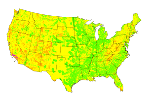
The political push to increase power generation from renewable sources, such as solar energy, requires knowing the best places to site new solar power plants with respect to the applicable regulatory, operational, engineering, environmental and socioeconomic criteria. To that end, scientists at the Oak Ridge National Laboratory GIS and Technology Group used remote-sensing data to map suitable areas for concentrated solar power (CSP) plants.
Using satellite data from NASA's Global Energy and Water Cycle Surface Radiation Budget project for estimating global solar radiation, the scientists developed a computational model built on a GIS platform that divides the study area into a grid of cells and estimates the site suitability value by computing a list of metrics based on applicable site requirements, such as population density, solar energy potential, federal lands and hazardous facilities. Overall, some 30 GIS datasets were used to compute eight metrics.
Results showed that about 11 percent of the contiguous United States has the highest suitability index to drive a steam turbine, and 24 percent is suitable to drive a Sterling engine, if the minimum global solar radiation is set at 6.0 kWh∕m2∕day. About 28 and 44 percent of the country, respectively, has the highest suitability index for these two applications if the minimum global solar radiation is set at 4.8 kWh∕m2∕day.
The full report can be accessed here.


