Tackling security and Public Safety Challenges across the United States SAN DIEGO - ideaForge Technology Inc. (a subsidiary of ideaForge Technology Limited), a leading global drone technology and manufacturing company, announces the launch of new innovative...
RouteSmart Technologies Launches Innovative Solution to Help Waste Collection Firms Service Alleys
COLUMBIA, Md.-RouteSmart Technologies, a leader in route planning and optimization solutions, has released a new suite of tools designed to enhance waste management services for clients who collect garbage and recycling in alleyways. This innovative feature in...
New American-Made Lightweight Professional Drone for Inspections and ISR
MISSOULA, Mont.- American drone maker Skyfish will unveil Osprey -- at Xponential Booth #4350 -- a new survey-grade, enterprise drone that fits in a backpack. Purpose built for infrastructure inspection and ISR, Osprey supports best-in-class, compact third-party...
Carahsoft and Arcadus Partner to Bring Digital Twins and 3D Spatial Data Solutions to Government Agencies
NASHVILLE, Tenn. and RESTON, Va.- Arcadus, a technology leader in the digital twin/3D spatial data market serving the Public Sector, and Carahsoft Technology Corp., The Trusted Government IT Solutions Provider®, today announced a strategic partnership. Under the...
Drone Nerds Partners with Anzu Robotics as New Drone Manufacturer Enters Market
Fort Lauderdale, FL- Drone Nerds, a leading consumer and enterprise drone solutions provider, has officially announced a strategic partnership with the newest drone manufacturer to join the industry, Anzu Robotics. Recently emerged in the drone industry, Anzu Robotics...
7 things to see at GEO Business
GEO Business, the UK's largest geospatial event, returns to ExCeL London on 5-6 June 2024. GEO Business is a platform for you to connect with the geospatial community and unlock the potential of geospatial innovation. This free-to-attend expo acts as...
e-GEOS to lead the consortium for the supply of geospatial products for the Copernicus Security Service component on Support to EU External Actions (SESA)
Rome- e-GEOS, a Telespazio (80%) / Italian Space Agency (20%) company, has been awarded by the European Union Satellite Centre (SatCen) for the renewal of the supply of geospatial products for the Copernicus Security Service component on Support to EU External and...
Virtual Surveyor Adds Planimetric Survey Functionality to Latest Release of Smart Drone Surveying Software
Faster Overall Workflow AARSCHOT, Belgium – Virtual Surveyor has enhanced its popular smart drone surveying software with new planimetric survey capabilities. In addition to multiple performance modifications, Virtual Surveyor version 9.5 now enables users to...
Northern Plains UAS Test Site Celebrates 10-Year Anniversary
FAA-Designated Test Site and Leaders to Join Presentations at AUVSI XPONENTIAL GRAND FORKS, North Dakota – Known for results and innovation, the Northern Plains UAS Test Site marks its 10th anniversary this year. The Federal Aviation Administration-designated...
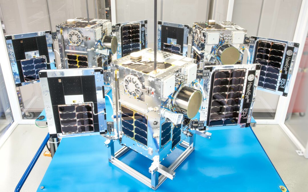
Successful Deployment of HawkEye 360 Microsatellite Clusters 8 and 9
Space Flight Laboratory (SFL) confirmed that six radio frequency geolocation microsatellites developed for HawkEye 360 of Herndon, Va., successfully communicated with ground control.