CENTENNIAL, Colo.- CompassData, the supplier of the largest commercially available archive of photo-identifiable ground control, today announced a partnership with Carahsoft Technology Corp., the trusted government IT solutions provider. Under the agreement, Carahsoft...
Aerojet Rocketdyne Welcomes Mohammed Khan as Senior VP of the Defense Business Unit
SACRAMENTO, Calif. - Aerojet Rocketdyne, a subsidiary of Aerojet Rocketdyne Holdings, Inc. (NYSE:AJRD), today announced that Mohammed A. Khan, Jr. has joined the company as senior vice president of its recently formed Defense Business Unit. A photo accompanying this...
Remembering the First Earth Day Celebration in 1970
April 22, 2017 marks the forty-seventh anniversary of Earth Day. Suzanne M. Avena, Chair of the Environmental Practice Group at Garfunkel Wild, P.C., remembers being in downtown Manhattan, New York for the auspicious first Earth Day on April 22, 1970 – just one of...
Aerojet Rocketdyne Helps Deliver Resupply Mission to International Space Station
SACRAMENTO, Calif.- Aerojet Rocketdyne, Inc., a subsidiary of Aerojet Rocketdyne Holdings, Inc. (NYSE:AJRD), helped propel the Orbital ATK Cygnus cargo spacecraft on its seventh operational delivery flight under the NASA Commercial Resupply Services contract,...
National Geospatial-Intelligence Agency Awards Boundless with $36M Contract
NEW YORK, NY – Boundless, the leader in open GIS, today announced that it has been awarded a $36 million contract by the National Geospatial-Intelligence Agency (NGA), the primary source of GEOINT for the U.S. Department of Defense and the U.S. Intelligence...
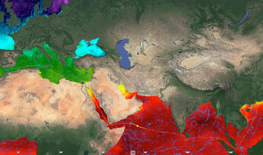
Satellites Locate Optimal Shipping Paths
With approximately 90 percent of world trade carried by ships, ensuring a vessel follows the fastest route has obvious economic benefits. By merging measurements from different satellites, the European Space Agency (ESA) is providing key information on ocean currents to make shipping more efficient and help reduce carbon dioxide emissions.
Trumbull Unmanned Using SimActive for Emergency Response
Montreal, Canada, April 18th, 2017 – SimActive Inc., a world-leading developer of photogrammetry software, is pleased to announce that Trumbull Unmanned is using Correlator3D™ as part of their emergency response services. This includes rapid mapping of oil spills...
High Eye Aerial Imaging Acquired by Alta Vista Ventures Enhances UAV Mapping Opportunities
High Eye Aerial Imaging, based in Wasaga Beach, Ontario serves as the area’s source for unmanned aerial vehicle surveying, providing mapping of remote sites, aerial surveys, volumetric calculations, digital elevation modeling, and many other services has recently...
DigitalGlobe, Hitachi Ink Reseller Agreement for Satellite Imagery Distribution in Japan
US: DigitalGlobe has entered into a commercial reseller agreement with Hitachi for the distribution of the former’s satellite imagery products and services in Japan, a news agency reported on Monday. Hitachi will serve as exclusive reseller and Japan Space Imaging...
A Novel Solution for 3D Mapping Construction Sites: Put a Camera on a Crane
After making its name on the drone photogrammetry market, Pix4D is working its way into solutions designed specifically for construction–and some of those solutions are very creative. First, some background: Pix4D offers a BIM solution built on existing...
