BOTHELL, Wash.-EagleView Technology Corporation (“EagleView®â€), a leading technology provider of aerial imagery, data analytics and GIS solutions, is encouraged by recent developments in its ongoing litigation against Xactware and Verisk for infringement of...
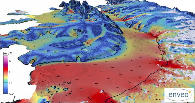
Satellites, Study Track Antarctic Ice Loss
More than two decades of observations by five radar satellites show the acceleration of ice loss of 30 glaciers in Western Palmer Land in the southwest Antarctic Peninsula.
Teledyne Optech Holding Free Workshop at GEO Business UK
May 9, 2017 — Teledyne Optech is pleased to announce that it is displaying its latest airborne and terrestrial lidar solutions for acquiring accurate geospatial data at GEO Business 2017 in London on 23-24 May 2017, and is holding a workshop on survey efficiency...
Unmissable Conference Line-Up Featuring Keynote Presentations from HS2's Sadie Morgan, Ordnance Survey's CEO Nigel Clifford, & ESRI’s Charles Kennelly
Leading organisations from across the geospatial industry, including Ordnance Survey, Google, HS2, Department of Transport, ARUP, ESRI, AGI, and the RICS, will feature prominently in GEO Business’ 2017 Conference programme. Returning to the Business Design Centre in...
World's Largest Satellite Fleet Owner Joins The Geological Remote Sensing Group
The Geological Remote Sensing Group (GRSG) has expanded its membership once again with the recent news that Planet; the owners and operators of the world’s largest commercially-operated fleet of satellites, has joined as the Group’s latest corporate member.  ...
Wantman Completes Extensive UAV Project with SimActive
Montreal, Canada, May 9th, 2017 – SimActive Inc., a world-leading developer of photogrammetry software, is pleased to announce that Wantman Group, Inc. has completed a 9 square mile UAV project using Correlator3D™.  Initially meant to be acquired using manned...
XPONENTIAL 2017 Innovation Preview Debuts, Take a Sneak-Peak at the Most Innovative Unmanned Systems Technologies
JACKSONVILLE, Fla., and ARLINGTON, Va – Aero-News Network (ANN) and the Association for Unmanned Vehicle Systems International (AUVSI), the host of XPONENTIAL 2017, the largest trade show for the unmanned systems and robotics industry, today announced the debut of...
Esri and UNOSAT Host GIS for a Sustainable World Conference
REDLANDS, Calif.- Esri, the global leader in spatial analytics, and the United Nations Institute for Training and Research’s (UNITAR) Operational Satellite Applications Programme (UNOSAT), will host the GIS for a Sustainable World Conference May 9 through 11 in...
PCI Geomatics to Present OBIA and InSAR Papers at ISRSE-37
MARKHAM, Ontario, Canada - PCI Geomatics, a world-leading developer of remote sensing and photogrammetric software and systems, announced today it will present two papers at the 37th International Symposium on Remote Sensing of Environment (ISRSE) in Tshwane, South...
Tata Consultancy Services Launches First Drones Research Lab in Cincinnati, Ohio
CINCINNATI and MUMBAI, India - Tata Consultancy Services (TCS) (BSE: 532540, NSE: TCS), a leading global IT services, consulting and business solutions organization, has opened its first Drones Research Lab  in the US at its Seven Hills Park Innovation Center...
