SAN DIEGO - Geodetics Inc., a leading manufacturer of integrated Mobile Mapping Systems that utilize LiDAR, announced today plans to introduce innovative Point&Pixel™ capability to their Geo-MMS™ product offering. As a part of the company's long-term strategy...
Nevada UAS Test Site tests Advanced Artificially Intelligent Unmanned Aerial System (UAS) with Microsoft Researchers
HAWTHORNE, Nev. - The Nevada Governor's Office of Economic Development (GOED) and the Nevada Institute for Autonomous Systems (NIAS) has teamed up with Microsoft's Unmanned Aerial System (UAS) research team to test Artificial Intelligence (AI) in their 16 ½ -foot,...
Kratos' satID 3.20 Product Release Offers Industry's Only TDMA Network Geolocation Capability to Combat VSAT Interference
SAN DIEGO - Kratos Defense & Security Solutions, Inc. (Nasdaq:KTOS), a leading National Security Solutions provider, announced today that its market leading satID® satellite interference geolocation product offers the industry’s only TDMA network geolocation...
Transport Canada Adds Multiple senseFly Drones to List of Compliant Systems
Cheseaux, Switzerland – senseFly’s eBee Plus, eBee SQ and albris drones have been added to Transport Canada’s list of “Compliant Unmanned Aerial Vehicles (UAV)â€, a distinction that allows Canadian organisations using senseFly drones to apply for Compliant...
Atlas Dynamics to Launch Autonomous Professional Drone System with 55-Minute Flight Time at InterDrone 2017
Atlas Dynamics (http://www.atlasdynamics.eu), a leading provider of drone-based solutions for the professional user, announced today that it will showcase live demonstrations of its market-ready autonomous professional drone, the Atlas Pro, at InterDrone 2017. On the...
Drone Delivery Canada Announces U.S. Market Listing
TORONTO - Drone Delivery Canada 'DDC or the Company' (CSE:FLT), is pleased to announce that its common shares commenced trading on the OTCQB Venture Market in the United States under the symbol "TAKOF" as of August 22, 2017. "Listing on the OTCQB market is part of our...
2017 Awards for Excellence in Public Safety GIS Recipients Recognized at the National Geospatial Preparedness Summit
WASHINGTON - The National Alliance for Public Safety GIS (NAPSG) Foundation Board of Directors is pleased to announce Major General William N. Reddel of the New Hampshire National Guard, Richard Butgereit of Florida's Division of Emergency Management, and Chad Council...
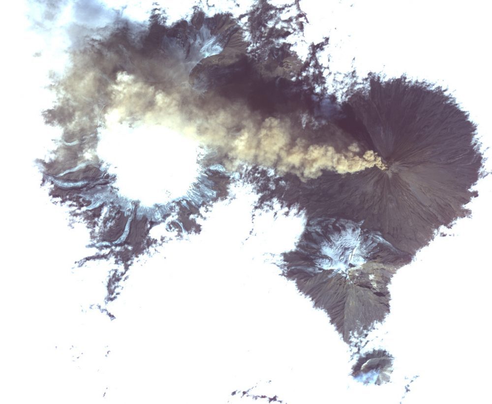
Satellite Images Erupting Russian Volcano
Shiveluch, one of the world’s most active volcanoes, is seen poking through above a solid cloud deck, with an ash plume streaming to the west.
Caliper Corporation: 2017 Sustained Growth
NEWTON, MASSACHUSETTS (USA) - Caliper Corporation, founded in 1983 and headquartered in Newton, MA (USA), is a technology leader in the development of geographic information systems (GIS) and transportation mapping software. Our sustained growth has been noted by an...
1Spatial Grows its Team of Safe Software FME Certified Trainers
1Spatial Platinum Partner of Safe Software and value added reseller of FME is delighted to announce that Thomas Farrington, Consultant with 1Spatial Australia, has been awarded Safe Software's FME Certified Trainer accreditation. The FME Certified Trainer...
