Retailers and manufacturers face the continual challenge of positioning their products in the market regions where they are most wanted. Our 2017 data on retail purchasing power illuminates the areas of Germany with the highest spending potential for various product...
NASA Awards SSL Next Phase Funding for Dragonfly On-Orbit Assembly Program, Demonstrates Confidence in Public Private Partnership for Space Robotics
Palo Alto, CA. - SSL, a leading provider of innovative satellites and spacecraft systems, today announced that NASA has awarded the next phase of funding for its ground-breaking Dragonfly on-orbit satellite assembly program. The contract modification to move forward...
GEO Business 2018: Over 75% of Space Already Booked for UK's Largest Geospatial Event
GEO Business – the UK’s largest geospatial exhibition and conference, is well on track for another successful edition next year, when it returns to the Business Design Centre, in London, on 22-23 May 2018. Since its record-breaking 2017 event, just over three...
MDA Celebrates Historic Space Robotic Milestone on Mars Rover Curiosity
Brampton, ON – MacDonald, Dettwiler and Associates Ltd. (“MDA†or the “Companyâ€) (TSX:MDA), a global communications and information company, celebrates a milestone achievement of the successful operation of the MDA-built Alpha Particle X-Ray Spectrometer...
Brainnwave Makes Data Available to Support Disaster Relief
Edinburgh, September 2017-Â start-up Brainnwave believe that people make better decisions if they have quick and simple access to the data they need, at the time they need it. With the catastrophic events of recent natural disasters, the Brainnwave team decided to...
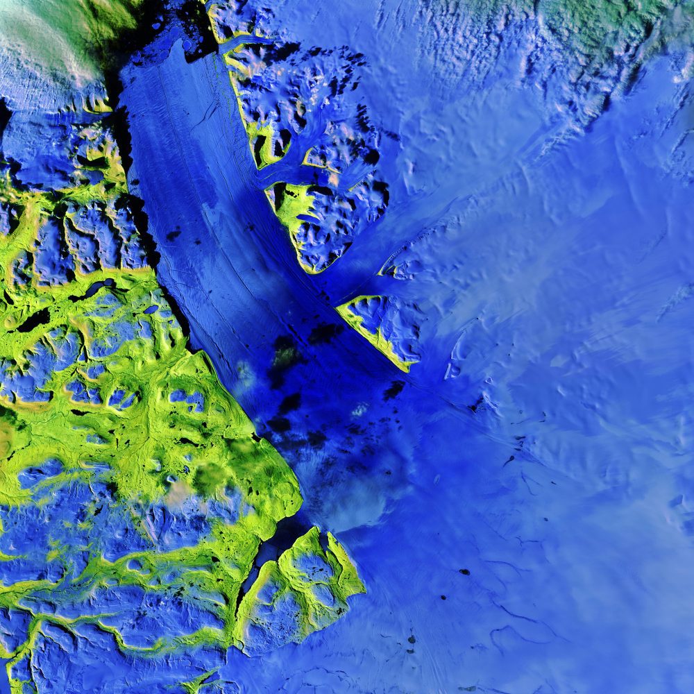
Satellite Tracks Cracks in Greenland Glacier
The Copernicus Sentinel-2A satellite takes us over the Petermann Glacier in northwest Greenland in this false-color image captured on Aug., 16 2017.
Airborne Mapping System from 3D Laser Mapping Takes Off
3D Laser Mapping, the industry leader in geospatial technology, is helping survey teams to cover more ground in a shorter space of time with a new aerial mapping system. The ROBIN +WINGS Airborne LiDAR system is an extension of the market leading ROBIN mobile mapping...
CoreLogic Analysis Shows an Estimated 8.5 Million Properties in Florida at Significant Risk of Potential Wind Damage from Hurricane Irma
IRVINE, Calif.- CoreLogic® (NYSE: CLGX), a leading global property information, analytics and data-enabled solutions provider, today released data analysis which shows that an estimated 8,456,455 residential and commercial properties in Florida are at either...
USC To Host International Academic Conference on Digital Approaches to Genocide Studies
 LOS ANGELES - USC Shoah Foundation Center for Advanced Genocide Research, in collaboration with the USC Digital Humanities Program, will host an international conference in October that will focus on the opportunities and challenges presented by the advancement of...
Sentera’s Omni Drone Offers Agriculture Industry Third Layer of Crop Health Insight
MINNEAPOLIS -Â Sentera, a leading designer and manufacturer of remote-sensing technologies for precision agriculture, today announced the capability of its Omni quadcopter drone to capture three distinct crop health data measurements in a single flight: thermal,...
