Simple GIS Software, LLC has announced that it has released version 9.5 of its Simple GIS Client Application, a lightweight but powerful desktop GIS software for Windows PCs, laptops, and tablets.   Simple GIS Client is a very affordable GIS application for...
BAE Systems to Host Media Briefings on Combat Vehicles and Precision Munitions at AUSA Annual Meeting
BAE Systems will highlight a range of technologies and capabilities to meet U.S. and allied military needs at the 2017 Association of the United States Army (AUSA) Annual Meeting and Exposition, held October 9-11 at the Walter E. Washington Convention Center in...
Leidos Announces Winners of Inaugural Supplier Innovation & Technology Symposium Awards
RESTON, Va.- Leidos (NYSE: LDOS), a FORTUNE 500® science and technology leader, today announced the recipients of the inaugural Supplier Innovation & Technology Symposium awards. The awards honor excellence in technology, collaboration, partnership and...
Drone Guarder, Inc. Announces Negotiations for a Strategic Partnership with Leading Drone Technology Company
LONDON - Drone Guarder, Inc. (OTCQB:DRNG): Drone Guarder (DG) is pleased to announce negotiations for a strategic partnership to share commercial and technology platforms with a leading European drone technology company. The basis of our partnership will be a...
Verisk’s Geomni Business Announces New Drone Service for Properties
Lehi, Utah - Geomni, a Verisk Analytics business (Nasdaq:VRSK), has announced a new service that allows customers to dispatch a licensed, qualified UAV (unmanned aerial vehicle) pilot to collect imagery and data about a structure. The information from the UAV...
Astun Technology Supports Ordnance Survey
Staff from Astun Technology, the leading provider of cloud-based open-source GIS solutions to local and central governments, will be attending every one of the Ordnance Survey ‘Public Sector Mapping Agreement Regional Events’ which are being held around the UK in...
Kenyan Government Mapping Mines with Correlator3D
Montreal, Canada, October 3rd, 2017 – SimActive Inc., a world-leading developer of photogrammetry software, is pleased to announce that the Directorate of Resource Surveys & Remote Sensing (DRSRS) under the Ministry of Mining in Kenya is using Correlator3D™...
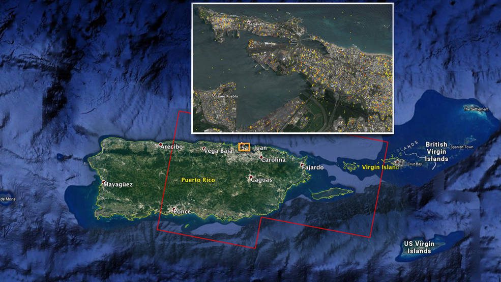
NASA Damage Map Aids Puerto Rico Hurricane Response
A NASA-produced map showing areas of eastern Puerto Rico that were likely damaged by Hurricane Maria has been provided to responding agencies, including the Federal Emergency Management Agency (FEMA).
GRM FieldForms Connects Intelligent Data Collection in the Field to the Cloud
JERSEY CITY, NJ – GRM Information Management, a leader in enterprise content management and records management, has introduced FieldForms. FieldForms is the latest advancement in GRM’s SaaS-based Intelligent Forms technology that incorporates intelligence behind...
GeoMax Releases All-In-One Office Software for Topographical Data
Widnau, SWITZERLAND: GeoMax, professional surveying and construction product provider, announced today the X-PAD Office Fusion, the all-in-one office software combining data from multiple sensors into one easy-to-use interface X-PAD Office Fusion software manages,...
