Bruchsal, Germany, October 25, 2017 – GfK has released its Europe Map Edition 2017/2018, which includes thousands of updates to the previous year’s edition. The digital maps reveal Europe’s current administrative and postcode boundaries. As such, they provide...
ESA and Radiant.Earth Join Forces to Advance Sustainable Development Goals
FRASCATI, Italy and WASHINGTON, Oct. 25, 2017 - The European Space Agency (ESA) and Radiant.Earth announce their agreement to jointly enhance geospatial data literacy in the global development community to support tracking the Sustainable Development Goals (SDGs)....
Aerojet Rocketdyne Breaks Ground On New Era of Advanced Manufacturing in Huntsville
HUNTSVILLE, Ala. - Aerojet Rocketdyne, a subsidiary of Aerojet Rocketdyne Holdings, Inc. (NYSE:AJRD), marked a key milestone today when it officially broke ground on a new, 136,000-square-foot manufacturing facility located in Huntsville, Alabama. During a ceremony,...
Parrot Bebop-Pro Thermal
Parrot Bebop-Pro Thermal is an all-in-one quadcopter thermal imaging solution specifically designed for small construction businesses, thermal inspection professionals and public safety services. This solution enhances Parrot’s Professional range of business...
IDS GeoRadar Unveils Ground Penetrating Radar to Improve Safety Before Cutting or Drilling into Concrete Structures
Pisa, Italy – IDS GeoRadar, a leading provider of multi-frequency, multi-channel Ground Penetrating Radar (GPR) and interferometric technology solutions worldwide, today launched C-thrue, a radar-based technology solution specifically developed to support...
Saudi Ministry of Interior Supports Hajj and Umrah Safety with Hexagon Safety & Infrastructure's Intergraph Computer-Aided Dispatch Solution
Huntsville, Alabama – The Kingdom of Saudi Arabia Ministry of Interior supported the safety of pilgrims and residents during the Hajj and Umrah seasons of 2016 and 2017 by deploying Hexagon Safety & Infrastructure’s Intergraph® Computer-Aided Dispatch (I/CAD)...
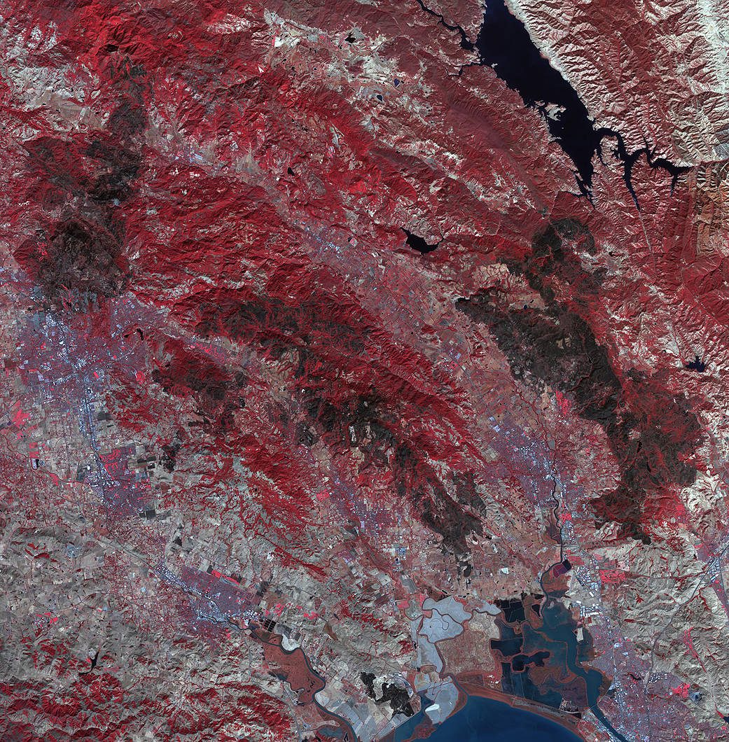
Impact of Northern California Fires Seen in New NASA Satellite Image
As firefighters continue to work toward full containment of the rash of wildfires burning in Northern California, a new image from the Advanced Spaceborne Thermal Emission and Reflection Radiometer (ASTER) instrument on NASA’s Terra satellite shows the growing fire scar on the landscape.
Black & Veatch and Aeryon Labs Partner to Provide End-To-End Aerial Asset Inspection Solution
Las Vegas, Nevada (24 OCTOBER 2017) – Black & Veatch and Aeryon Labs announced today that they have launched an end-to-end asset management inspection solution leveraging drone technology for global energy clients. Aeryon’s commercial unmanned aerial system...
InfoGeographics Navigator for Geocortex Essentials 2.0 Released
InfoGeographics (IGI) has released InfoGeographics Navigator for Geocortex Essentials (INGE) Version 2.0. This is a FREE utility offered by InfoGeographics, Inc that simplifies access to and launching of the key software components, file system locations, and high...
Brampton Wins Award for Making Public Information More Accessible Using GIS
TORONTO, Esri Canada User Conference – The City of Brampton today received Esri Canada’s Award of Excellence for using geographic information system (GIS) technology to support their Open Government initiative. The City developed Brampton GeoHub, an open data...