Pisa, Italy – IDS GeoRadar, a leading provider of multi-frequency, multi-channel Ground Penetrating Radar (GPR) and interferometric technology solutions worldwide, today launched C-thrue, a radar-based technology solution specifically developed to support...
Saudi Ministry of Interior Supports Hajj and Umrah Safety with Hexagon Safety & Infrastructure's Intergraph Computer-Aided Dispatch Solution
Huntsville, Alabama – The Kingdom of Saudi Arabia Ministry of Interior supported the safety of pilgrims and residents during the Hajj and Umrah seasons of 2016 and 2017 by deploying Hexagon Safety & Infrastructure’s Intergraph® Computer-Aided Dispatch (I/CAD)...
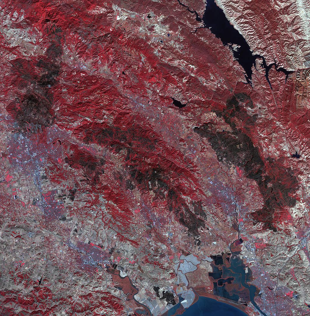
Impact of Northern California Fires Seen in New NASA Satellite Image
As firefighters continue to work toward full containment of the rash of wildfires burning in Northern California, a new image from the Advanced Spaceborne Thermal Emission and Reflection Radiometer (ASTER) instrument on NASA’s Terra satellite shows the growing fire scar on the landscape.
Black & Veatch and Aeryon Labs Partner to Provide End-To-End Aerial Asset Inspection Solution
Las Vegas, Nevada (24 OCTOBER 2017) – Black & Veatch and Aeryon Labs announced today that they have launched an end-to-end asset management inspection solution leveraging drone technology for global energy clients. Aeryon’s commercial unmanned aerial system...
InfoGeographics Navigator for Geocortex Essentials 2.0 Released
InfoGeographics (IGI) has released InfoGeographics Navigator for Geocortex Essentials (INGE) Version 2.0. This is a FREE utility offered by InfoGeographics, Inc that simplifies access to and launching of the key software components, file system locations, and high...
Brampton Wins Award for Making Public Information More Accessible Using GIS
TORONTO, Esri Canada User Conference – The City of Brampton today received Esri Canada’s Award of Excellence for using geographic information system (GIS) technology to support their Open Government initiative. The City developed Brampton GeoHub, an open data...
4DMapper Incorporates Global Mapper SDK Enabling Cloud Based Geospatial Analytics
Hallowell, Maine - Blue Marble Geographics (bluemarblegeo.com) is pleased to announce that 4DMapper (4dmapper.com ), a geospatial technology company based in Australia, has chosen the Global Mapper Software Development Kit (SDK) as the engine behind its online data...
AllTerra Sud Offers Microdrones mdMapper Packages for Professional Aerial Surveying
DETTELBACH, Germany -Â Microdrones is honored to announce a new partnership with AllTerra Sud, leading provider of geospatial equipment to South Germany. In addition to Bavaria, Baden-Wurttemberg, Hesse, and Rhineland-Palatinate, the Trimble Dealer will offer the...
CyberTech Systems and Software and Esri Agree to Power GeoShield, Intelligence Led Policing Spatial Analytics with ArcGIS Server via OEM
OAK BROOK, Ill. -Â CyberTech Systems and Software, a leader in providing next-generation Spatial and Advanced Analytic Solutions and Digitalization platforms and Esri, pioneering ArcGIS, the world's most powerful mapping and analytics software have entered into an OEM...
Teledyne Optech and Teledyne DALSA to Show Latest Imaging Solutions at ITS World Congress
Teledyne Optech and Teledyne DALSA are pleased to announce that they will showcase their latest imaging solutions for intelligent transportation systems in live demonstrations at the ITS World Congress in Montréal, Canada in booth 514. The summit takes place from...
