WESTMINSTER, CO and VANCOUVER - Maxar Technologies Ltd. ("Maxar" or the "Company", formerly MacDonald, Dettwiler and Associates Ltd.), (NYSE and TSX: MAXR), a leading global provider of advanced space technology solutions for commercial and government markets,...
Contex Introduces the Market's Widest and Fastest CCD Scanner
Alleroed, Denmark — Contex, the world leader in large format scanning, today introduces the HD Ultra X 6000, the widest, fastest and most productive 60-inch CCD scanner available in the market. Outperforming the competition with color matching and image scanning...
3D Repo's Adds Instant Clash Detection to Online BIM Platform
London, 14 June 2018 – Digital Construction technology provider 3D Repo has announced software that identifies clashes in construction plans by analysing 3D models submitted by project partners and contractors. The new Clash Detection functionality has been added to...
Sun Moon Lake National Scenic Area Administration Offers a Mobile Tour Guide App in Shueili Che-Cheng
Recently, the concept of “smart city†has been on the rise globally, with its peripheral products and applications becoming new favorites on the market. Supergeo is pleased that Sun Moon Lake National Scenic Area Administration also catches up this trend,...
OGC Calls for Participation in its Indoor Mapping and Navigation Pilot
The Open Geospatial Consortium (OGC) has released a Call for Participation to solicit proposals for the OGC Indoor Mapping and Navigation Pilot Initiative. The Indoor Mapping and Navigation Pilot, sponsored by the Public Safety Communications Research Division of the...
EarthSense Activates Zero Emission Vehicle Running to Reduce City Air Pollution
Leicester, UK – Air quality monitoring technology from EarthSense has provided real time data for trials into the use of low emission vehicles to improve air quality in polluted city centres. The data, collected by both mobile and static EarthSense Zephyr air...
Streamlining Automated Inspection Technology for Transportation
Avitas Systems, a GE Venture, provides state-of-the-art, robotic based autonomous and semi-autonomous inspection management, smart scheduling, and safety compliance. The Avitas Systems cloud based platform uploads inspection data from a wide variety of sensors, fuses...
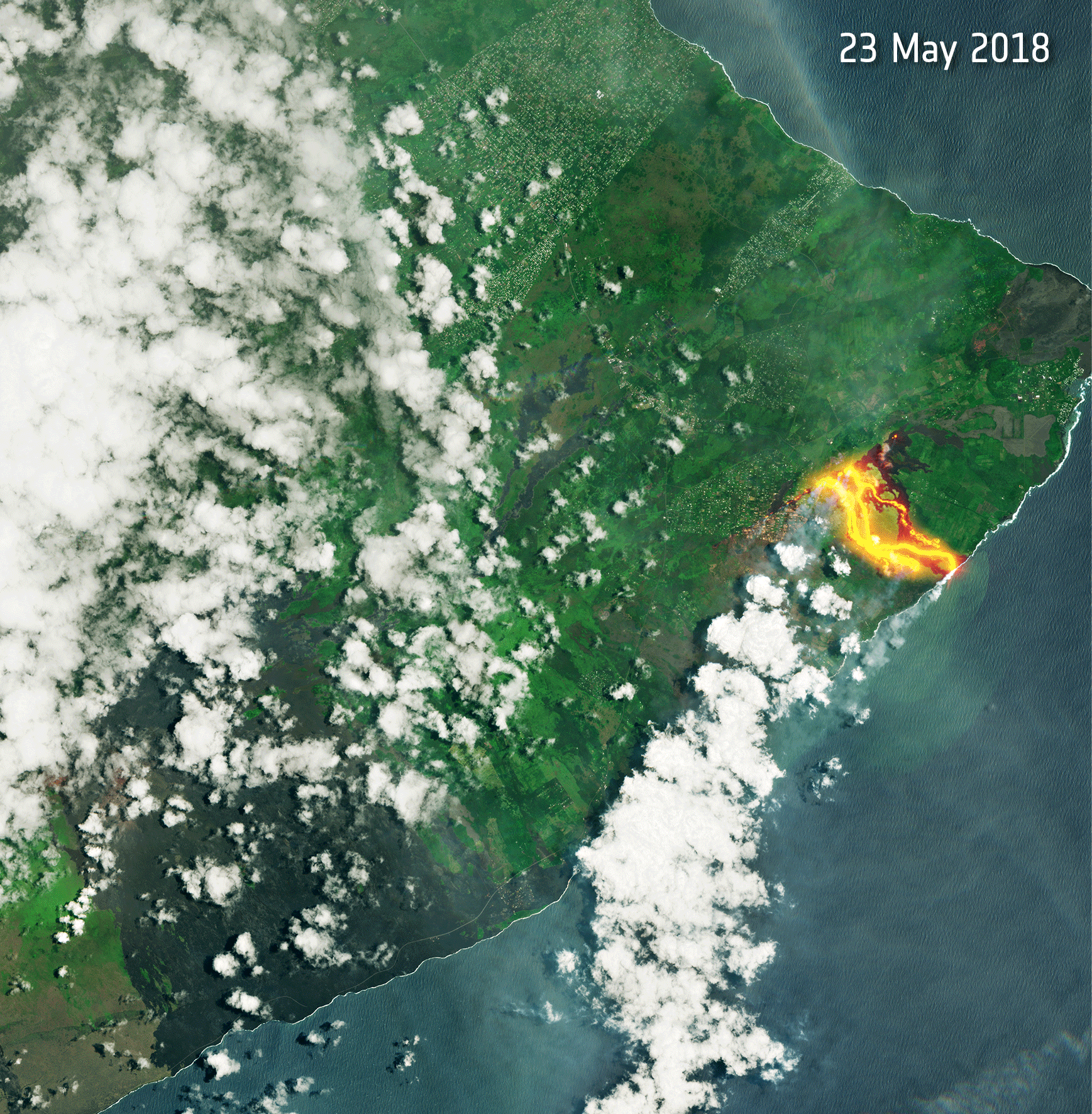
Restless Kilauea
Fiery lava continues to pour from the Kilauea volcano on Hawaii's Big Island. These Copernicus Sentinel-2 images from May 23, June 7, and June 12, 2018, show the relentless flow of lava and clouds of ash.
NSGIS and InfoGeographics announce Strategic Partnership
Los Angeles, CA –NorthSouth GIS LLC (NSGIS) and Traverse City, Michigan based InfoGeographics, Inc (IGI) have entered into a strategic partnership in the geospatial consulting and systems integration field. Headquartered in Los Angeles, NSGIS has been providing...
Esri and DigitalGlobe Provide Unprecedented View of World Cup
REDLANDS, Calif.- Esri, the global leader in spatial analytics, and DigitalGlobe today announced that they have created a Story Map of high-resolution imagery that visualizes the 12 venues being used for 2018 FIFA World Cup Russia, exclusive to The Associated Press....
