NORCROSS, Ga.– Hexagon’s Geospatial division announces that it is now an approved supplier for the Software for Innovation, Diversity and Evolution II (SIDE II) contract in the European Union (EU). Hexagon is now capable of helping EU agencies to best embrace...
Geospatial Expert Dan Wobbe, PLS, PIC, Joins Cardno’s Portland Office
Portland, OR - Cardno, Inc., is pleased to announce that Dan Wobbe, PLS, PIC, has returned to the firm as Regional Manager in the company’s Portland, OR, USA office. Dan brings over 30 years of surveying experience in areas such as boundary, location, construction,...
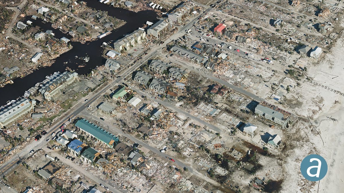
Remote Sensing Performs Damage Assessment following Hurricane Michael
SimActive Inc. partnered with Midwest Aerial to perform damage assessment of Hurricane Michael.
SimActive and Midwest Aerial Perform Damage Assessment following Hurricane Michael
Montreal, Canada, November 6th, 2018 – SimActive Inc., a world-leading developer of photogrammetry software, has partnered with Midwest Aerial to perform damage assessment of Hurricane Michael. Correlator3DTM was used to process large format imagery collected by...
Trimble Introduces Satellite-Based RTX Corrections to the Kestrel Seismogeodetic System for Earthquake, Volcano and Infrastructure Monitoring
LAS VEGAS - Trimble (NASDAQ: TRMB) announced today the addition of Trimble RTXâ„¢ technology delivered via satellite to its Kestrelâ„¢ seismogeodetic system. Pairing uninterrupted, high-quality Global Navigation Satellite System (GNSS) positioning corrections with...
Trimble Expands its Portfolio of GNSS Smart Antennas for Civil Construction
LAS VEGAS - Trimble (NASDAQ: TRMB) introduced today the new Trimble® SPS785 GNSS Smart Antenna, and dynamic tilt functionality for the Trimble SPS986 GNSS Smart Antenna. These releases expand the Trimble Site Positioning Systems portfolio with a new, more affordable...
Drone Industry Launches to New Heights with FT Aviator: Industry’s First Single-Handed, Precision Flight Controller with Advanced Camera Interfaces
HOUSTON -Â Drone pilots, from commercial experts to novices, can now increase their flight precision and improve their image/video quality with a first-of-its-kind single-handed controller from Fluidity Technologies. The FT Aviator drone controller was conceptualized...
Microdrones Acquires Service Provider Navmatica ME
DUBAI, United Arab Emirates - As part of an ongoing global expansion, Microdrones has acquired geomatics service provider Navmatica Middle East (ME). Since 2012, Navmatica ME has provided services and custom software development, with a focus on geodetic positioning,...
Tech Company Creates Striking Floating Maps”
New York-  Meridian Maps, a small startup based in Ridgewood, New York, has debuted a unique type of wall art. Dubbed “Floating Mapsâ€, they hover off the wall creating distinctive shadows. These custom works are precision laser-cut from hand-stained solid...
Maptitude achieves top ranking in G2 Crowd’s GIS Relationship and Small Business Relationship Index as well as second highest ranking in G2 Crowd’s GIS Usability Index
NEWTON, MASSACHUSETTS (USA) - Maptitude has achieved the highest GIS Relationship and Small Business GIS Relationship scores based on the responses of real users for each of the relationship related questions featured in the G2 Crowd review form. The Maptitude...
