Berlin, Germany, Nov. 20, 2013—BlackBridge’s RapidEye products are an active part of the Sentinel-2 project from the European Space Agency (ESA). The RapidEye data, provided free of charge, simulates the Sentinel-2 frequency and will support further development of...
First Damage Assessment Maps of the Philippines Released by the European Commission
ROME, Nov. 20, 2013—International NGOs and the UN will bring aid in the field using disaster maps issued by the the European Commission's Copernicus Emergency Management Service soon after Typhoon Haiyan violently struck the Philippines on the 8th of November. The...
2014 ASPRS Fellow Award Winners Named
Bethesda, Md., Nov. 19, 2013—Bon A. Dewitt, Rongxing Li, Richard A. Pearsall, Karen L. Schuckman and Douglas A. Stow have been named the 2014 ASPRS Fellow Award winners. The ASPRS designation of Fellow is conferred on active Society members who have performed...
Blue Marble to Exhibit at GeoDATA London Mapping Showcase
Hallowell, Maine, Nov. 19, 2013—Blue Marble Geographics (www.bluemarblegeo.com) will be exhibiting at the GeoDATA London Mapping Showcase at the ILEC Conference Centre on Thursday, November 28, 2013.  Blue Marble will be demonstrating low cost GIS using Global...
PCI Geomatics Celebrates GIS Day in Ottawa by Awarding Carleton University Student with Academic Achievement Award
RICHMOND HILL, Ontario, Canada, Nov. 21, 2013—PCI Geomatics, a world-leading developer of geoimaging software and systems, announced today that it presented an award to Carleton University student Rachel Plewes in recognition of her academic achievements. The award...
Astrium's Greenhouse Gas Emissions Measurement Service Included in UN Climate and Energy Action Hub
Nov. 21, 2013—A recently launched greenhouse gas emissions measurement service from Astrium, the world’s second largest space company, has been included in the Climate and Energy Action Hub, an interactive platform to encourage companies to collectively provide...
British Trade Delegation to Libya Taps Proteus for Mapping Expertise
ABU DHABI, UAE, and BRISTOL, UNITED KINGDOM, Nov. 20, 2013—Proteus, a provider of satellite-derived bathymetric mapping and seabed classification services, represented the mapping industry in a British trade delegation to Tripoli organized by the Libya-British...
East View Licenses “World Mapping Today” from DeGruyter
MINNEAPOLIS, Minn., Nov. 22, 2013—East View is pleased to announce that it will revive and add value to the content that makes up the authoritative reference work, "World Mapping Today, 2nd Edition" by R.B. Parry and C.R. Perkins. "World Mapping Today" has long been...
MDA to Provide RADARSAT-2 Digital Elevation Models to the Malaysian Government
Richmond, B.C. , Canada, Nov. 21, 2013—MDA’s Information Systems Group (MDA) announced today that it has signed a contract with Sky-Shine Corporation of Malaysia to deliver over 52,000 square kilometers of digital elevation products using space-based imagery from...
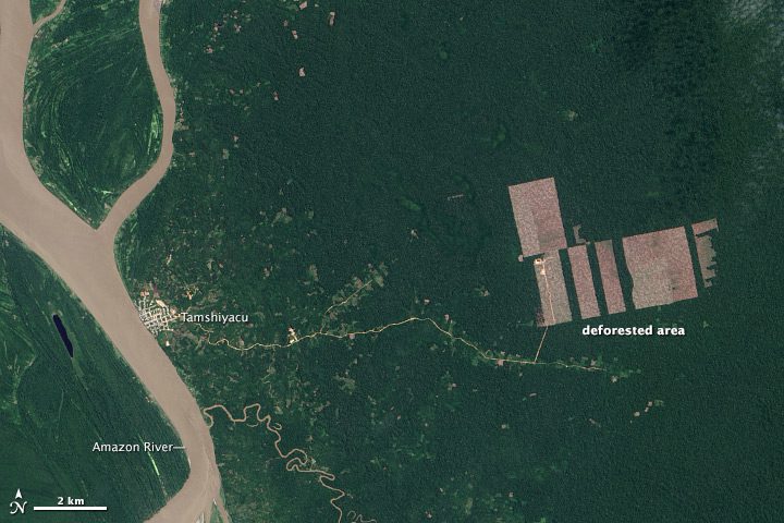
Landsat Satellites Quantify Deforestation in Peru
North Carolina State University researchers piecing together Landsat 7 and 8 satellite images estimate a deforestation rate of roughly 100 hectares (247 acres) per week in a tract they observed.
