ATLANTA, Dec. 19, 2013—Improving field utility worker efficiency and building on its advanced utility asset measurement offering, GE’s Digital Energy business (NYSE: GE) has announced it is branding ikeGPS’ innovative field measurement product as MapSight. This...
GeoCue Releases LP360 2013.2
Huntsville, Ala., Dec. 20, 2013—GeoCue (via its wholly owned subsidiary, QCoherent Software LLC) is pleased to announce LP360 2013.2, the second major release of LP360 for the 2013 calendar year. LP360 is the world’s most powerful and popular LIDAR extension for...
New Multi-INT System Delivers Actionable Intelligence
SAN DIEGO, Dec. 18. 2013—Intelligence professionals and military forces alike need to remain one step ahead of potential threats. That’s why we designed our new small size, weight, and power (SWaP) Multi-INT system to help allied forces quickly detect and track...
MAPPS Winter Conference Program to Address Technology, Business Development and Emerging Trends
Reston, Va., Dec. 19, 2013—With emerging technologies, regulations and business development key concerns of geospatial businesses, MAPPS (www.mapps.org), the association for private sector geospatial firms, today announced the program for its 2014 Winter Conference...
Visual Intelligence Expands Executive Management Team to Support Growth
Houston, Dec. 17, 2013—Visual Intelligence announced two appointments that expand the company’s executive team to support its rapid growth in the geospatial market. Phil Kern has been named the company’s Executive Vice President of Sales, and Kevin Brown will...
A Modern Compass Improves Oil Production
Reston, Va., Dec. 19, 2013—By using the Earth’s magnetic field, combined with new innovative technology, oil and gas drilling companies are increasing oilfield productivity while reducing development costs and environmental impacts. An article in the fall 2013...
Blue Marble Solidifies Partnerships with International Resellers
Hallowell, Maine, Dec. 17, 2013—Blue Marble Geographics (bluemarblegeo.com) is pleased to announce their partnerships with PT. Duta Astakona Girinda of Indonesia, NIK Insaat Ticaret Ltd. of Turkey and SMC Synergy of South Africa.  Blue Marble's geospatial data...
Quantum Spatial Partners with Hawkeye Helicopter for LiDAR Collection
Sheboygan, Wis., Dec. 19, 2013—Quantum Spatial, Inc. (formerly Aero-Metric, Inc.), has recently entered into a Master Services Agreement with Hawkeye Helicopter, LLC (Hawkeye) to provide precision helicopter-mounted LiDAR solutions to both Quantum Spatial and...
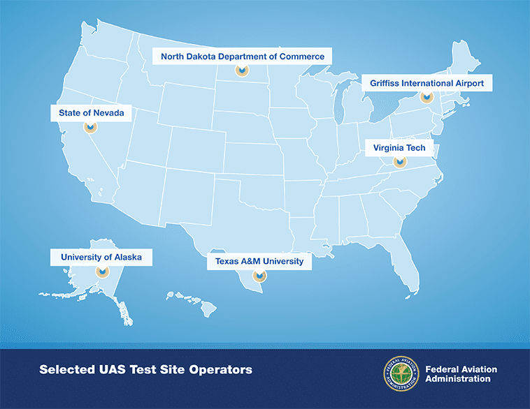
FAA Selects Six Sites for Unmanned Aircraft Research
After a rigorous 10-month selection process involving 25 proposals from 24 states, the Federal Aviation Administration selected six unmanned aircraft system research and test site operators across the country.

Tracing Ozone's Long Path to Recovery
The holes in the ozone layer over Antarctica in 2011 and 2012 are a study in contrasts. The 2011 hole ranked among the 10 largest recorded since the 1980s, whereas the 2012 hole was the second smallest.
