Washington, D.C., June 10, 2014—TerraGo, a leading provider of geospatial collaboration software, announced today a partnership with Beijing Space View Technology to help meet growing demand in China and better serve customers in that region. Beijing Space View...

Google Buys Skybox Imaging for $500 Million
Google agreed on June 10, 2014, to buy Skybox Imaging, a satellite imagery provider, as the technology giant continues its lofty ambitions for its Internet offerings.

FAA Approves First U.S. Commercial Drone
The Federal Aviation Administration (FAA) will permit energy company BP and unmanned aircraft system (UAS) manufacturer AeroVironment to fly a Puma AE UAS for aerial surveys in Alaska.

Sanborn Joins Battle against California Drought
California Water Service Company selected The Sanborn Map Company to leverage its geospatial data collection and remote sensing expertise against the state's severe drought.
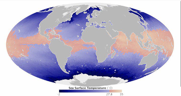
Satellites Take the Temperature of the Hurricane Pool
According to the meteorological calendar, hurricane season began on May 15, 2014, in the Eastern Pacific Ocean and on June 1, 2014, in the Atlantic Ocean. But are the oceans ready for the season?
Applanix, American Aerospace Advisors Announce Mapping Solution for Unmanned Aerial Vehicles
Orlando, Fla., May 13, 2014—Applanix Corp and American Aerospace Advisors Inc (AAAI) today announced  an OEM supply agreement that will incorporate Applanix’ industry-leading direct georeferencing technology into AAAI’s unmanned aerial platforms. The...
DMCii Demonstrates Remote Sensing for Carbon
Guildford, United Kingdom, May 21, 2014—British satellite imaging company DMC International Imaging Ltd (DMCii) today demonstrates their Technology Strategy Board supported project which has developed a ground-breaking new system to calculate carbon from Earth...
ArcGIS Runtime SDKs Increase Productivity
Redlands, Calif., May 20, 2014—Esri updated its ArcGIS Runtime Software Development Kits (SDKs) with improvements that will help increase your productivity. ArcGIS Runtime SDKs run on all major platforms and now have offline functionality. These SDKs provide tools...
Esri Supports OGC GeoPackage Encoding Standard
Redlands, Calif., May 15, 2014—Esri announces the support of the new Open Geospatial Consortium (OGC) GeoPackage Encoding Standard. This new OGC specification defines GeoPackages for exchange and GeoPackage SQLite Extensions for direct use of vector geospatial...
How Will 3DEP Benefit Your State?
Reston, Va., May 14, 2014—Want to know how elevation will benefit your state? The USGS National Geospatial Program is advancing the 3D Elevation Program, known as 3DEP, in response to the growing need for high-quality three-dimensional representations of the...
