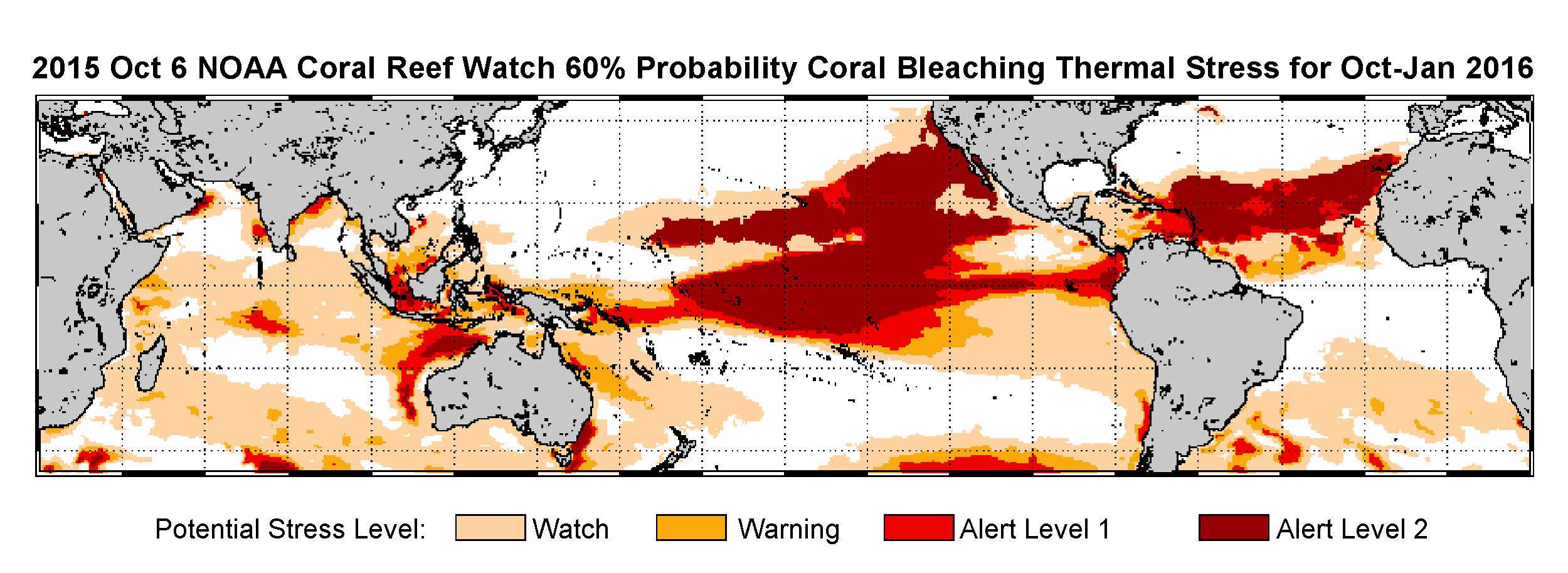
As record ocean temperatures cause widespread coral bleaching across Hawaii, NOAA scientists confirm the same stressful conditions are expanding to the Caribbean and may last into 2016, prompting the declaration of the third global coral-bleaching event ever on record.
JUPEM Earns Global Recognition for Ground-Breaking Smart Mapping Project
October 20, 2015 — JUPEM has received a prestigious Special Achievement in GIS (SAG) Award for their efforts to promote the use of geospatial information in Malaysia through a ground-breaking project called Geospatial Data Acquisition System (GDAS). The...
France #1 Civil Drone Manufacturer Released a New Long Range Data Modem
October, 20, 2015 (France) — Lehmann Aviation (www.lehmannaviation.com) released its new long range data modem, compatible with all L-A Series drones. With this new functionality, L-A Series drones (especially the LA300 for mapping and surveying) gain the same...
Global Mapper LiDAR Module V17 Released with New Noise Filtering and Power Line Extraction Tools
Hallowell, Maine, October 20, 2015 — Blue Marble Geographics (bluemarblegeo.com) is pleased to announce the immediate availability of an update to the Global Mapper LiDAR Module. Offered in conjunction with the recent release of Global Mapper version 17, Blue...
Teledyne Optech Boosts Presence in China with General Manager Wenjie Wang
October 20, 2015 — Teledyne Optech is pleased to announce that Wenjie Wang has joined the company in the position of General Manager for China. In his new position, Wenjie will work in Teledyne’s growing office in Beijing to provide his in-depth experience to...
First annual Commercial UAV Expo gets Sky-High Marks from Industry Insiders
October 19, 2015 (Portland, Maine, USA) — Commercial UAV Expo’s launch October 5-7, 2015 was lauded as a huge success for precision measurement professionals who gathered for three days of education, networking, and buying and selling solutions at a conference...
Eye on Earth Summit Calls for Practical Actions to Support Informed Decision-Making and the 2030 Sustainable Development Agenda
Abu Dhabi, October 19, 2015 — The second Eye on Earth Summit, held last week, has concluded with a commitment by delegates to implement a number of mechanisms, recommendations and practical actions around the supply, demand and enabling conditions of data considered...
Exclusive Keynote Presentation at the Capturing Reality Forum in November
October 19, 2015 — The The Capturing Reality Forum, which takes place at the Salzburg Congress in Salzburg, Austria, from 23-25 November 2015, is pleased to announce its prestigious keynote speaker, Professor Luc Van Gool, founder and head of the Computer Vision...
1Spatial Wins IRLOGI Award with Ordnance Survey Ireland
Cambridge, UK, October 19, 2015 — (www.1spatial.com) 1Spatial, the global spatial software firm which manages the world’s largest spatial data, has won the IRLOGI Space and Place award for Most Innovative use of Technical Infrastructure in a GI Solution. The...
African Satellite Constellation Expecting New Addition
Image-sensor developer Teledyne Dalsa is partnering with South Africa-based Denel Spaceteq, a high-performance satellite systems and solutions provider to the African and international aerospace market, to develop a new multispectral image sensor for advanced Earth observations.