If water main breaks, there is an electricity outage, a pothole is found on the street or there is an incident at a large sporting event people will often post about it on social media. This data can be key in improving response...
concept3D Announces Launch of atlas3D Mapping and Interactive Media Platform
BOULDER, Colo., - concept3D, Inc., a leader in location-based software development and 3D media services, today announced the launch of atlas3D, a powerful new mapping and interactive media platform built to promote and market facilities and locations. On the surface,...
Sanborn Completes Connecticut Statewide Data Collection
COLORADO SPRINGS, Colo., - The Sanborn Map Company, Inc. (Sanborn) flight team overcame challenging spring weather conditions to successfully collect high-resolution imagery of the entire state of Connecticut and its coastline in just five weeks. Altogether, the...
NGCC and Esri Provide Access to Authoritative Chinese Cartographic Maps and Imagery
Redlands, California —The world’s leading mapping platform company, Esri, and the National Geomatics Center of China (NGCC) held a signing ceremony in Beijing, China with respect to providing access to NGCC’s mapping web services. This historic agreement will...
exactEarth and DigitalGlobe Partner to Combat Illegal and Unreported Fishing
CAMBRIDGE, ON, June 14, 2016 - exactEarth Ltd. (TSX: XCT) (the "Company"), and DigitalGlobe Inc. (NYSE:DGI), today announced a Strategic Alliance (the "Alliance") to offer joint services to the commercial fishing industry and to aid in the combating of Illegal,...
LuxCarta Joins CM-CIC Investissement and BNP Paribas Développement to Support its Expansion
Based in Sophia-Antipolis, France, LuxCarta specializes in processing satellite images to create 3D models. The company was created by the merger of GeoImage and ComputaMaps in 2013. Following the departure of one of LuxCarta's four co-founders and associates, the...
Michael Baker Takes Lead in GIS for Next Generation 9-1-1, Partners With Orleans Parish Communication District, LAGIC on Innovative Technology
PITTSBURGH, PA- Michael Baker International, a global leader in engineering, planning and consulting services, today announced a partnership with the Orleans Parish Communication District (OPCD) and Louisiana Geographic Information Center (LAGIC) to supply the Michael...
CubeSat Satellite Testing Takes Off at Mount Stromlo
Researchers from around Australia have begun testing satellites at the Mount Stromlo space testing facilities at The Australian National University (ANU) ahead of a mass satellite launch from the International Space Station later this year. Three CubeSats, satellites...
Airbus Announces New Options for Streamlined Imagery Access
On June 13, 2016, Airbus Defence and Space formally introduced its One Atlas, One Tasking initiatives to help make satellite data access and procurement easier and more efficient for users.
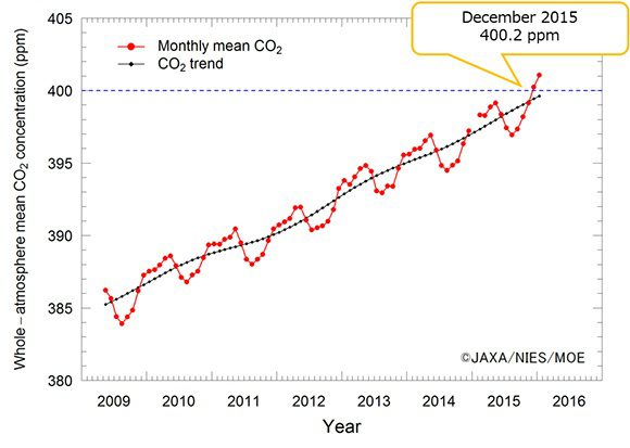
GOSAT Records Highest Carbon Dioxide Concentrations
A recent analysis of data from the Greenhouse gases Observing SATellite IBUKI (GOSAT) shows that the global atmospheric monthly mean CO2 concentration observed vertically through the whole atmosphere exceeded 400 ppm in December 2015 for the first time since GOSAT was launched in 2009.
