Aerial Hyperspectral Survey Assesses Alaskan Minerals

Aerial Hyperspectral Survey Assesses Alaskan Minerals

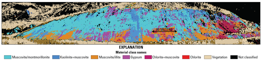
Although Alaska contains vast mineral deposits, its size and remoteness have prohibited study and extraction of these resources. To remedy this, the U.S. Geological Survey (USGS) began the Alaska Hyperspectral Project to assess the applicability of hyperspectral surveying to rapidly acquire data about the distributions of surficial materials, including different types of bedrock and ground cover.

USGIF Names New Board Members

Herndon, Virginia, July 11, 2016 —The United States Geospatial Intelligence Foundation (USGIF) is excited to announce two additions to its Board of Directors—Dr. L. Roger Mason Jr. and Carmen Medina. Both Mason and Medina began their three-year terms in June....

Vexcel Imaging and Orbit GT Sign Reseller Agreement

Graz, Austria and Lokeren, Belgium, July 8, 2016 — Vexcel Imaging has signed an agreement with Orbit GT as a new Reseller of Orbit GT Oblique, Mobile Mapping and Indoor Mapping software products. Alexander Wiechert, CEO of Vexcel Imaging, is looking forward to the...

Luciad Geospatial User Conference 2016

Belgium, Leuven  - Luciad today announces its 2016 User Conference, the premier event for geospatial professionals and developers from the Aviation, Defence, Maritime, Safety & Security and Utilities & Logistics sectors on September 28th & 29th at Square...

ESA's Dragon Cooperation with China Extended to 2020

ESA and China have launched the fourth phase of the collaborative Dragon programme in Wuhan City, on the Yangtze River, which recently experienced major floods witnessed by Europe’s Sentinel-1 satellite. ESA and representatives of China’s Ministry of Science and...

NEWEST V1 MEDIA PUBLICATION

April Issue 2024