Paris, Washington D.C., Montreal, Yokohama, July 7, 2016Â - According to Euroconsult's latest report, Prospects for the Small Satellite Market, we are on the cusp of a major revolution for the space sector and overall space ecosystem, as more than 3,600 smallsats are...
Enhanced Imagery, Modelling, Volumes Improve Productivity with LISTECH Neo
MELBOURNE, AUSTRALIA, 6 July 2016 – LISTECH, a Hexagon Geosystems brand, today announced increased functionality to its new geospatial software Neo, with terrain modelling, volume calculation and imagery offerings. With an integrated 3D/2D environment for viewing of...
DJI GO App Now Includes GEO Geofencing System
NEW YORK - DJI, the world's leading maker of unmanned aerial vehicles, Tuesday introduced an improved version of its geofencing system in the latest update to the DJI GO app that controls its Phantom and Inspire aerial platforms. The industry-leading Geospatial...
IARPA Announces the Multi-View Stereo 3D Mapping Challenge
Washington, D.C. – The Intelligence Advanced Research Projects Activity, within the Office of the Director of National Intelligence, announced that today marks the launch of the Multi-View Stereo 3D Mapping Challenge. The challenge aims to foster a community of...
Copernicus Accelerator Seeking Applications
Until July 18, 2016, the European Commission is taking applications from individuals and teams from startups, SMEs, industrial companies, research institutes and universities for its Copernicus Accelerator, which hopes to foster development of commercial space applications and products.
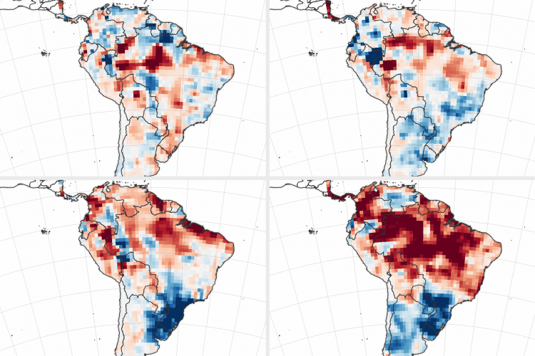
Amazon Basin Drought Upping Fire Risk
In South America's Amazon basin, El Niño conditions in 2015 and early 2016 reduced rainfall during the wet season, leaving the region drier at the start of the 2016 dry season than any year since 2002.
RIEGL USA to Attend 2016 MAPPS Summer Conference!
Join MAPPS in beautiful Traverse City, Michigan for education and networking at the 2016 MAPPS Summer Conference! The 2016 MAPPS Summer Conference will be held at the Grand Traverse Resort in Traverse City, Michigan from July 16-20, 2016. RIEGL USA will...
The Channel Syndicate Subscribes to InsitePro for Underwriting US Flood Insurance
DENVER - Intermap Technologies®, a leading provider of location-based intelligence solutions, today announced an InsitePro subscription from the Channel Syndicate, an underwriter in the Lloyd’s insurance marketplace. Syndicates at Lloyd’s underwrite business...
European Satellite Navigation Competition “ Extended Submission Phase
The submission phase for the ESNC 2016 is going into extra time. Interested participants have the chance to submit, complete or improve their ideas until 09:00 am (CEST) Monday, 11 July 2016 at www.esnc.eu. As the larges GNSS-related innovation network, the annual...
Dewberry Assesses East Coast Flood Damage through Aerial and Satellite Photography Interpretation
Dewberry, a privately held professional services firm, has completed a Federal Emergency Management Agency (FEMA) contract to interpret aerial and satellite imagery and assess damages in South Carolina following a record-breaking storm event in late 2015. In October...
