Leica Geosystems today announced that SmartNet North America (www.smartnetna.com), the industry-leading high-precision, high-availability network RTK correction service, has merged with the Pleiades reference station network in Western Canada, operated by Pleiades...
INTERGEO TV in August
As the international information platform for the geocommunity, INTERGEO TV is showcasing various topical productions on the news portal www.intergeo-tv.com in August. The August edition of the News (online from 4 August) explores the extent to which geodata and...
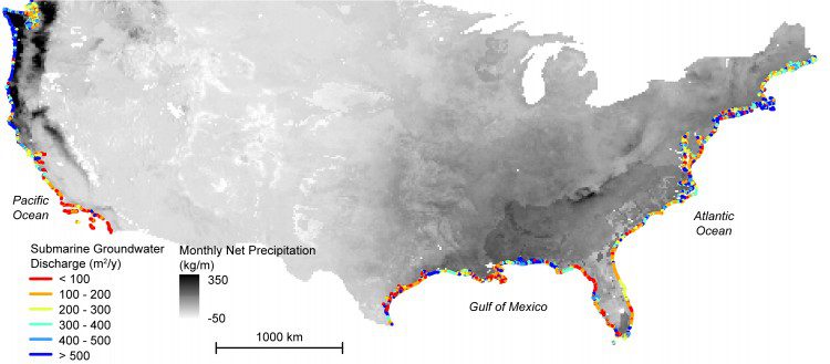
Study Maps Hidden Water Pollution in U.S. Coastal Areas
Coastal waters and nearshore groundwater supplies along more than a fifth of coastlines in the contiguous United States are vulnerable to contamination from previously hidden underground transfers of water between the oceans and land.
OGC Adopts SensorThings API Part 1: Sensing Standard
09 August 2016 - The Open Geospatial Consortium (OGC®) has adopted SensorThings API Part 1: Sensing as an official standard. The OGC SensorThings API provides an open, geospatially enabled way to interconnect Internet of Things (IoT) devices, data, and applications...
DHS Announces $40M Funding Opportunity for Homeland Security Quantitative Analysis COE
WASHINGTON – The Department of Homeland Security (DHS) Science and Technology Directorate (S&T) today announced a $40M funding opportunity for an institution to lead a new DHS Center of Excellence (COE) for Homeland Security Quantitative Analysis. DHS S&T is...
Dewberry Awarded Geographic Information System Contract with Hanover County
Dewberry, a privately held professional services firms, was recently selected for a geographic information systems (GIS) contract with Hanover County, Virginia. The firm will provide general GIS consulting services to Hanover County on an as-needed basis and help...
Point Grey’s New Spinnaker SDK Leverages GenICam3 for Faster Application Development
Richmond, BC, Canada – Point Grey, a global leader in high-performance digital cameras for industrial and scientific applications, today announced the release of its new Spinnaker software development kit (SDK) to simplify and accelerate the creation of new vision...
New Blackfly S Family Packs the Latest Imaging Technology into a Compact Housing
Richmond, BC, Canada – Point Grey, a global leader in innovative, high-performance digital cameras for industrial and scientific applications, today announced the release of Blackfly S, a new family of USB3 Vision and GigE Vision cameras designed to meet complex...
Global Mapper for Oil and Gas Presentation at Denver PUG
The Denver Petroleum User Group (PUG) will be holding their annual meeting on Thursday, August 11 and Blue Marble is pleased to announce that Mike Childs, lead developer of Global Mapper, will be speaking at the event. Scheduled from 3:00 to 4:00 pm, Mike’s...
Cityworks Announces the Release of Cityworks 15.1
Sandy, UT – Cityworks announces the release of Cityworks 15.1, making the care of critical infrastructure, capital assets, and property easier and more straightforward than ever. Cityworks 15.1—Platform 4.1 introduces Cityworks “apps†—functional...
