Using data from NASA's Time History of Events and Macroscale Interactions during Substorms (THEMIS) satellites, scientists have observed Earth's vibrating magnetic field in relation to the northern lights in the night sky over Canada.
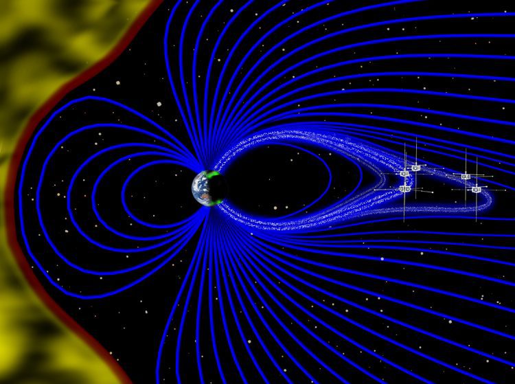
Using data from NASA's Time History of Events and Macroscale Interactions during Substorms (THEMIS) satellites, scientists have observed Earth's vibrating magnetic field in relation to the northern lights in the night sky over Canada.
September 13, 2016 — Teledyne Optech is pleased to announce that Chief Scientist Dr. Viktor Feygels will attend the Oceans 16 MTS/IEEE conference in Monterey, California on September 22 to present the object-detection capability of the Optech CZMIL Coastal Zone...
Exprodat, the oil and gas ArcGIS platform specialist, Esri Gold Partner and Getech group company, has released the latest version of its popular Data Assistant software, which simplfies and speeds up the process of importing and exporting common exploration data, to...
NASHVILLE, Tenn. — Now, more than ever, Mapfolio lets you navigate and personalize your ArcGIS Online experience with ease. Simplify your search by creating personalized landing pages that filter only the content your users need, allowing them to engage in fewer...
Leuven, Belgium and Torrance, Calif. – Sept. 12, 2016 – Septentrio, a leading provider of accurate and reliable GNSS solutions, today announces the launch of its most advanced GNSS receiver for dedicated time and frequency transfer applications, the PolaRx5TR. The...
Geospatial Media and Communications is glad to introduce Trimble Navigation Limited as the Strategic Sponsor for Geospatial World Forum 2017, which is scheduled to take place from January 23th- 25th, 2017, in the city of Hyderabad, India. As a Strategic...
Tel Aviv, Israel – VisionMap, a leading provider of airborne imaging systems, announced its exclusive partnership with Special Operations Solutions, LLC (SOS). SOS, which specializes in providing solutions for all parts of the ISR and remote sensing life cycle, will...
BUFFALO GROVE, Ill.— Leica Microsystems, a technology leader with a 160-year history of providing best-in-class precision microscopy and digital micro-imaging solutions, announces a strategic expansion in its market representation in the Southeastern United...
NEW YORK — Growth in the commercial drone market is largely dependent on policy and regulatory framework in various major developing and developed countries across the globe. Over the next decade, rapidly evolving drone technology is expected to transform the...
Redlands, California—Global smart-mapping leader Esri has partnered with the United Nations Foundation’s Nothing But Nets campaign in the fight against malaria.Malaria claims the life of a child every two minutes, despite being both preventable and treatable....
