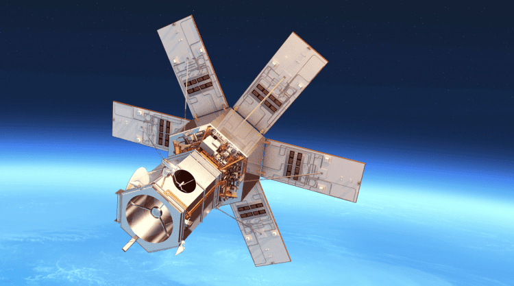
On Nov. 11, 2016, DigitalGlobe's WorldView-4 commercial imaging satellite was launched aboard an Atlas V rocket from Vandenberg Air Force Base, Calif. About 45 minutes after launch, satellite signals indicated it was in proper position and working order.
AgPixel Brings High-Resolution Imagery to the agX Platform
STILLWATER, OK - AgPixel® is offering agronomists the ability to seamlessly integrate high-resolution imagery via the agX Platform®. "AgPixel is excited to release high-resolution imagery through the agX Store," said Kirk Demuth, Chief Operating Officer for AgPixel....
Trimble Adds Automated Cloud Processing Service to Trimble Connect to Deliver High-Quality Information from Big Data Systems
LAS VEGAS - Trimble (NASDAQ: TRMB) announced today new data processing capabilities for Trimble Connectâ„¢ software, a cloud-based collaboration ecosystem. The automated solution uses the scalable processing power of the cloud to significantly reduce time to delivery...
RIEGL to Attend AU Las Vegas 2016!
Orlando, FL -Â AU Las Vegas 2016 will be held at the Venetian in Las Vegas, Nevada from November 15-17, 2016. Please join the RIEGL experts at Booth 2926 to learn about the RIEGL product portfolio for terrestrial, mobile, airborne, and unmanned based laser scanning....
Esri Publishes New Edition of Map Use: Reading, Analysis, Interpretation
Redlands, California—Esri, the global leader in smart mapping, has published Map Use: Reading, Analysis, Interpretation, eighth edition. Esri president Jack Dangermond called the 650-page textbook "a comprehensive primer for using maps effectively." Map Use teaches...
Asteri Navigation Launches X-Series of Wearable GNSS Receivers at 2016 Autodesk University
Asteri Navigation will introduce a new line of rugged, compact and fully integrated GNSS receivers on November 15 at the 2016 Autodesk University in Las Vegas. Designed for geospatial field data collection and inspection applications that require high accuracy...
Bluesky 3D Laser Maps AONB for Archaeological Studies
Aerial mapping company Bluesky has used aircraft mounted lasers to create 3D maps of potentially important archaeological sites in Devon, England. Funded by Historic England (formerly English Heritage), the LiDAR surveys were commissioned by Devon County Council’s...
AT&T and NASA Collaborate on Drone Traffic Management System
VIENNA, Va. -Â AT&T* and the National Aeronautics and Space Administration (NASA) are researching traffic management solutions for Unmanned Aircraft Systems (UAS). The goal is an Unmanned Aircraft System Traffic Management (UTM) solution that supports the safe and...
CloudCities Provides Interactive 3D Conference Map for Autodesk University 2016
San Francisco/Zurich – CloudCities will provide the interactive 3D conference map for Autodesk University (AU) 2016, which will be displayed on multiple large screens at the venue. The 3D map hosted on CloudCities gives an overview of the events and exhibits –...
ADC WorldMap Releases Digital Atlas Version 7.3
Appleton, WI-USA – American Digital Cartography, Inc., a leader in providing comprehensive, current, and seamless geographic digital data for the whole Earth, is pleased to announce the release of ADC WorldMap Digital Atlas v7.3. The latest release includes...